Visual Materials
A New and Complete Map of the West Indies Comprehending all the Coasts and Islands Known by that Name

You might also be interested in
Image not available
A New Map of South America, Divided into its Several Provinces &c
Visual Materials
Kashnor dates as ca. 1778. Cartouche: Draped with net. Table of political divisions.. "Drawn From the most approved Geographers, with great Improvements from the Sieurs. D'Anville & Robert." Prime meridian: London. Relief: pictorial. Projection: Azimuthal. Printing Process: Copper engraving. Other Features: Cartouche. Verso Text: MS note: 851.
105:851 M

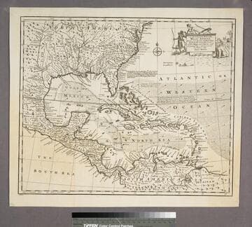
A New Map of the West Indies; or the Islands of America in the North Sea
Visual Materials
Kashnor notes, :Shows the coast of present-day Texas, and locates the Acansa and Teaucas Land, 'The People about this river are continually in Wars with the Spaniards'." Four harbor submaps. Submaps: A Draught of the Bay & City of Havana; The Bay of Porto Bella; A Draught of the Sity of Cartogena, its Harbour & Forts; La Vara Cruz. Cartouche: Soldiers, battle.. " With the Adjacent Parts, Explaining what belongs to England, Holland, Spain, France, &c. Also the Several Tracts made by the Gallions and Flota. by N. Vischer of Amsterdam. Is now done into English with many Considerable improvements according to the Newest and Best Observations." Prime meridian: Ferro. Relief: pictorial. Graphic Scale: Miles, leagues. Projection: Cylindrical. Printing Process: Copper engraving. Other Features: Sub-mapsCartouche.
105:800 M
An Accurate Map of the West Indies
Visual Materials
Kashnor notes, "Includes Florida, Georgia, Carolina, Virginia, and Maryland. Also shows the coast of New Leon and present-day Texas." Kashnor dates as ca. 1767. RLIN record suggests 1747. Cartouche: Natives & Lion.. "Drawn from the best Authorities, assisted by the most approved Modern Maps and Charts, and regulated by Astronomical Observations. By Eman. Bowen." Prime meridian: London. Relief: pictorial. Graphic Scale: Miles. Projection: Azimuthal. Printing Process: Copper engraving. Other Features: Cartouche. Verso Text: MS note:943.
105:943 S
Image not available
A New and Accurate Map of Paraguay, Rio de la Plata, Tucumania Guaria &c
Visual Materials
Kashnor notes, "Shows a note on the Jesuit settlement in Paraguay, said to contain about 300,000 families." Kashnor dates as ca. 1760. RLIN record suggests a date of 1747. Cartouche: Indians and traders.. "Laid down from the latest Improvements, and Regulated by Astronomical Observations, by Eman Bowen." "No. 127 (lower left)" Prime meridian: London. Relief: pictorial. Graphic Scale: Miles. Projection: Azimuthal. Printing Process: Copper engraving. Other Features: Cartouche. Verso Text: MS note: 926.
105:926 M

New Map of the West Indian Islands, as they are Possessed by the European Powers
Visual Materials
Kashnor ontes, "Indicates the English, Dutch, French, and Spanish possessions." Cartouche: branches.. "Drawn from the most Recent Authorities." Prime meridian: London. Relief: pictorial. Graphic Scale: Leagues. Projection: Cylindrical. Watermark: Crowned fleur-di-lis VI. Printing Process: Copper engraving. Other Features: Cartouche. Verso Text: MS note: 966.
105:966 M
Image not available
New Map of the North-East Coast of Asia and North-West Coast of America, with the late Russian Discoveries
Visual Materials
Kashnor notes, "ca. 1770." This map appears to be a reduced size English copy of Gerhard Müller's map. Minimal cartouche.. Prime meridian: Ferro & London. Relief: pictorial. Graphic Scale: No. Projection: Pseudocylindrical. Printing Process: Copper engraving. Other Features: Cartouche.
093:046 S