Visual Materials
The Great River Marazon or of the Amazons Geographically describ'd by Samuel Fritz Missioner on the Said River
You might also be interested in
Image not available
Map of Terra Firma Peru, Amazone-land, Brasil & the North P. of LaPlata. By H. Moll Geographer
Visual Materials
Kashnor dates as ca. 1716. However, map 093:704, an apparent duplicate, is dated 1729. MS note: 878 (on backing). Prime meridian: London. Relief: pictorial. Graphic Scale: Miles. Projection: Cylindrical. Printing Process: Copper engraving.
105:878 S
Image not available
A map of the Dutch colonies of Surinam and Barbutius, and the French Colony of Cayenne : between the Orinoko and Amazon Rivers, in South America
Visual Materials
MS note: 920 (on backing). Prime meridian: London. Relief: pictorial. Graphic Scale: Miles. Projection: Cylindrical. Printing Process: Copper engraving. References: Jolly Lond-229;.
105:920 S
Image not available
Carte de la Nouvelle Angleterre, Nouvelle York, Nouvelle Jersey, et Pensilvanie
Visual Materials
Kashnor dates as ca. 1720. This is a French copy of Moll's 1720 map. RLIN record suggests publication may have been as late as 1756. "Pl 20." (upper right). "2[?]" (lower right). MS note: 576 (on backing). Prime meridian: Ferro. Relief: pictorial. Graphic Scale: Leagues. Projection: Cylindrical. Printing Process: Copper engraving.
105:576 S

A new and accurate map of the present seat of war in North America, from a late survey
Visual Materials
Kashnor notes, "A scarce map, issued during the early part of the Revolution." Kashnor dates c.1776. RLIN record places publication in London and appearance in Universal Magazine. MS note: 107 (on backing). Prime meridian: Ferro. Relief: pictorial. Graphic Scale: Miles. Projection: Cylindrical. Watermark: Two seals. Printing Process: Copper engraving.
105:107 S

The West Indies According to the best Authorities
Visual Materials
Kashnor notes: "Includes the coast of present-day Texas, New Leon, Louisiana and Florida." "Engraved for Guthries new System of Geography." Prime meridian: London, Ferro. Relief: pictorial & hachures. Graphic Scale: Miles, leagues. Projection: Cylindrical. Printing Process: Copper engraving. Verso Text: MS note: 802.
105:802 S
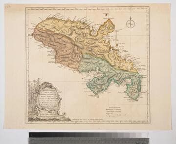
Martinico, one of the Caribbee Islands, in the West Indies; Subject to the French. according to Observations of Mr. Houel Engineer, by Thos. Jefferys, Geographer ti His Royal Highness the Prince
Visual Materials
Kashnor dates ca. 1760. Cartouche: framed with sugar cane. MS note: 813. Prime meridian: Ferro, London. Relief: hachures. Graphic Scale: Miles, leagues. Projection: Cylindrical. Watermark: Crowned fluer-di-lis over IVC. Printing Process: Copper engraving. Other Features: Cartouche. Verso Text: M
093:813 S