Visual Materials
Map of Terra Firma Peru, Amazone-land, Brasil & the North P. of LaPlata. By H. Moll Geographer
You might also be interested in
Image not available
Map of Terra Firma Peru, Amazone-land, Brasil & the North P. of LaPlata. By H. Moll Geographer 1729
Visual Materials
See 105:878 for another copy. MS note: 704 (on backing). Prime meridian: London. Relief: pictorial. Graphic Scale: Miles. Projection: Cylindrical. Printing Process: Copper engraving. Verso Text: MS note: 704 (on backing).
093:704 S
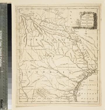
A new and accurate map of the province of Georgia in North America
Visual Materials
Kashnor notes," An old map published about 1775, shewing the roads and Indian paths." Kashnor dates c.1775. Duplicate map to 093:094S, 093:391. RLIN record notes date as [1779?] and place of publication as [London?] and as appearing in The Universal Magazine of 1779. MS note: 103 (on backing). Prime meridian: [Ferro]. Relief: pictorial. Projection: Cylindrical. Watermark: Crowned circular seal. Printing Process: Copper engraving.
105:103 S
Image not available
Florida Called by the French Louisiana &c. By H. Moll Geographer 1728
Visual Materials
Kashnor notes, "Locating the fort built by LaSalle at Bay St. Louis in 1685, the routes of Chevallier in 1687, the routes of Denis in 1713 and 1716, and Iberville's settlement founded in 1717, an interesting map." MS note: 426 (on backing). Prime meridian: London. Graphic Scale: Miles. Projection: Cylindrical. Printing Process: Copper engraving. Verso Text: MS note: 426 (on backing).
093:426 S
Image not available
A Map of the Islands of Orleans with the Environs of Quebec
Visual Materials
A duplicate of map 093:329. Kashnor dates as ca. 1760. MS note: 676 (on backing). Relief: hachures. Graphic Scale: Miles. Projection: Plane. Printing Process: Copper engraving.
105:676 S
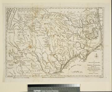
New and Accurate Map of North Carolina, and Part of South Carolina, with the Field of Battle between Earl Cornwallis and General Gates
Visual Materials
Duplicate of 093:074S. This copy stamped "Owens College Library, Manchester." Prime meridian: London. Relief: pictorial. Graphic Scale: Miles. Projection: Cylindrical. Watermark: Crowned oval. Printing Process: Copper engraving. Verso Text: MS note: 76 (on backing).
105:076 S
Image not available
Carolina by H. Moll Geographer 1729
Visual Materials
Kashnor notes, "A good map of the Carolinas, probably the last issued before the erection of the Georgia Colony. It locates the battles with Indians in Bath County under Col. Barnwell, and in Granville County under Col. Craven." See 093:378 for another map from this same volume with matching worm holes. Worm holes lower edge. MS note: 360 (on backing). Original backing between map and later backing material.. Prime meridian: London. Relief: pictorial. Projection: Mercator. Printing Process: Copper engraving. Verso Text: MS note: 360 (on backing).
093:360 S