Visual Materials
A New Map of Asia
You might also be interested in
Image not available
A New Map of the English Empire in America viz Virginia, New York [etc.]. Revised by Jon Senex, 1719
Visual Materials
Kashnor notes, "a rare and important map." This is the second & last state of the Morden map, see 105:541M, only the cartouche is changed. Cartouche surmounted by dedication. Submaps: The Harbour of Boston or Massachusetts Bay; A General map of the Coasts and Isles of Europe, Africa, and America. "I. Harris sculp: Dedication: Most humbly Inscrib'd ti Herver Edgly Herver of Clapham Esq. &c." Prime meridian: London. Relief: pictorial. Graphic Scale: Miles. Projection: Pseudocylindrical. Watermark: Fleur-di-lis. Printing Process: Copper engraving. Other Features: Sub-mapsCartouche. References: Tooley (Amer) p.63, #20. Verso Text: MS note: 542.
105:542 M
Image not available
A New Map of Virginia Mary=Land And the Improved Parts of Penn=sylvania & New=Jersey
Visual Materials
Kashnor notes, " Senex brought this map up to date. The plate was formerly used by Thornton, Lea, and Morden." "Most humbly Inscrib'd to the Right Hon. the Earl of Orkney &c. Knight of the Most Noble and Anciet Order of Thistle 1719." See 105:821M for the earlier version. This version includes Longitude scale which 105:821 lacks. RLIN record gives date of this version as 1721. Cartouche with tobacco.. Prime meridian: London. Relief: pictorial. Graphic Scale: Miles (leagues). Projection: Plane. Watermark: Fleur-di-lis AB. Printing Process: Copper engraving. Other Features: Cartouche. References: Tooley (Amer.) p.104; Phillips M. p.980.. Verso Text: MS note: 822.
105:822 M
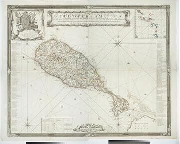
A New and Exact Map of the Island of St. Christopher in America
Visual Materials
One map on four sheets. Cartouche: Vined columns. Jams. Mynde Sculp. Dedication: Military decorations. Table: An Alphabetical List of the Subscribers Names. Submap: The Leeward Caribee Islands. Table of areas of each Parish.. "According to an Actual and Accurate Survey made in the Year 1753. Describing the several Parishes with their respective limits, Contents, & Churches, also the high ways, the Situation of every Gentleman's Plantation, Mills and Houses; with the Rivers, and Gutts. Likewise the Bays, Roads, Rocks, Shoals and Soundings that Surround the Whole. By Saml. Baker Lieutenant in His Majesty's Navy." "To the Right Honble. The Lords Commissioners for Executing the Office of Lord High Admiral of Great Britain &c. This map is most humbly Dedicated By their Lordships most Obedient humble Servt. Saml. Baker." Relief: pictorial. Graphic Scale: Miles. Projection: Plane. Printing Process: Copper engraving. Verso Text: MS notes: 7, 8, 9, 10 778 four sheets.
105:778 M

Carta Estatta rappresentante l'Isola di Cuba estratta dalle Carte del Sigr. Poppler
Visual Materials
Kashnor dates as ca. 1740. RLIN record suggests 1763, notes place of publication. Cartouche: flowered. MS note: 749 (on backing). Prime meridian: London. Relief: pictorial. Projection: Cylindrical. Printing Process: Copper engraving. Other Features: Cartouche. Verso Text: MS note: 749 (on backing).
093:749 S
Image not available
Chart of the Sea coasts of New=England New=Jarsey Virginia Maryland and Carolina From C. Cod to C. Hatteras By John Seller Hydrogr. to the King
Visual Materials
Kashnor notes, "Shows a good map of New York and Long Island, showing many towns." Five coats of arms and open shield. Kashnor dates as [1675]. McCorkle confirms 1675 date and gives appear in information. Later added MS notes showing additional towns and boundaries. Cartouche with Indians, open dedication shield lower right.. Relief: no. Graphic Scale: Leagues, miles. Projection: Cylindrical. Watermark: Leaf, lettering. Printing Process: Copper engraving. Other Features: Cartouche. References: McCorkle 675.6. Verso Text: MS note: 478.
093:478 M

Novissima et Accuratissima Insulae Jamaicae Descriptio per Johannem Sellerum. Hydrographum Regium Londini
Visual Materials
A catalogue of settlers and their locations. Kashnor dates as [1675]. See 093:802 for another copy. Cartouche: Coat of Arms, figures, empty dedication cartouche. Table: A Catalogue of the Severall Precincts, with the most Eminent Settlements therin, marked and numbered as followeth. Relief: pictorial. Graphic Scale: Miles. Projection: Cylindrical. Printing Process: Copper engraving. Other Features: Cartouche. Verso Text: MS note: 463.
105:463 M