Manuscripts
Map of subdivision of Rancho La Cañada

You might also be interested in

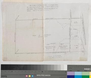
Map Partition of Ro. La Cañada
Manuscripts
Bordered by Rancho San Pascual. Shows parcel numbers, distances, markers; notations. Followed by. Alt. title supplied by cataloger.
mssSolano SR_Box_20(11).06
Image not available
Part of boundary between ranchos la Cañada and San Rafael
Manuscripts
Bordered by Rancho San Rafael. Shows stations, parcel letters, numbers; with table of stations, courses, distances data
mssSolano SR_Box_20(11)
Map of the Lands in the Rancho San Pedro
Manuscripts
...Partitioned in Case No. 15,697 [within document]; shows courses, distances, acreage, parcel owners, lot numbers, markers. Alt. title supplied by cataloger.
mssSolano SR_Box_23(14).01

Northern boundary of Rancho La Cañada
Manuscripts
Bordered by Rancho San Pascual [Pasqual] & Rancho Tujunga. Indicates lots, acreages and owners: Frank D. Lanterman, Roy S.Lanterman, La Cañada Land & Water Co.. Hachures of land features. Var. 13° 39' East. Inset map: T. 2 N.R.13 W.
mssSolano SR_Map_0034.01

Plat of most of Crescenta Cañada
Manuscripts
Original survey by F.D. Lanterman; showing lettered & numbered tracts and parcels; courses & distances, survey notes on lot ; & block particulars. Copied by Barrows.. Alt. title supplied by cataloger.
mssSolano SR_Box_20(11).09

Rancho la Cañada: S86, northern boundary : part of boundary between ranchos la Cañada and San Rafael
Manuscripts
Shows stations, parcel letters, numbers; with table of stations, courses, distances data.Title supplied by cataloger.
mssSolano SR_Box_20(11)