Manuscripts
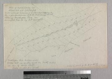
Northern boundary of Rancho La Cañada

You might also be interested in

Rancho la Cañada : S86, northern boundary - sketch maps
Manuscripts
Showing T. 1 N. R. 12 W. & T. 2.N.R.13 W. with section numbers, courses, distances, surface details; also sketches of parcels on tablings for survey and within W.H. Norway Field notes. Title supplied by cataloger.
mssSolano SR_Box_20(11).04
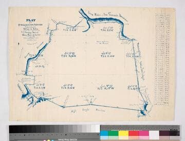
Map of subdivision of Rancho La Cañada
Manuscripts
Bordered by Ranchos Tujunga, San Rafael. ...as partitioned between J.L. Lanterman & reps of A.W. Williams, showing Michigan Avenue; parcel numbers, distances, markers, courses. Alt. title supplied by cataloger.
mssSolano SR_Box_20(11).08
Plat of the ex Mission of San Fernando
Manuscripts
Bordered by Santa Susana Mtns., Sierra Madre or San Fernando Mtn., Tujunga Rancho, Rancho San Rafael, Providenicia y Cahuenga, High Rough Mtn., Rancho Las Virgenes. Finally confirmed to Eulogio de Celis . . . Var. 13° 30' East. Inset of table with courses & distances.
mssSolano SR_Map_0141
Image not available
Rancho la Cañada: S86, northern boundary
Manuscripts
The collection consists of maps, field books, legal documents, business papers, and diaries related to the work of surveyors George Hansen, Alfred Solano, Sidney B. Reeve, and others. The maps and surveys in the collection are of the city of Los Angeles, Southern California ranchos, and subdivisions of the city of Los Angeles and neighboring towns. The collection contains over maps and sketch maps. Other subjects represented in the collection include: civil engineering, land subdivision, mines and mineral resources, and daily life in Los Angeles and Los Angeles County.
mssSolano

Plat of the Rancho La Cienega o Paso de la Tijera finally confirmed to Tomas Sanchez et al
Manuscripts
Bordering Ranchos Cienega, Ballona, San Ysidero Cañada de Los Bueyes, Aguaje de Centinela (Ygnacio Machado). T 2 S.R. 14 W.,Var. 14° E.. Windsor Hills, View Park areas. Color highlighting, hachures. Insets: two tables - Meanders of the Zanja del Rodeo de Enmedio; Boundaries of the Rancho La Cienega o Paso de la Tijera.
mssSolano SR_Map_0039

Crystal Springs
Manuscripts
Los Angeles River. Rancho de los Felis. Miniature version of previous map: Tract sold by C. V. Howard to the LA City Water-Works Co.. Var. 14° 30' E.; T. 1 N.R. 13 W.
mssSolano SR_Map_0068