Visual Materials
A Chart of the Road and Harbour, of Great Placentia in Newfoundland
You might also be interested in
Image not available
A Chart of the Bay of Placentia, on the South Coast of Newfoundland
Visual Materials
"Surveyed by Order of Commodore Shuldham, Governor of Newfoundland, Labradore, &c. by Mich. Lane, 1772.""Engraved by Faden & Jefferys Geographer to the King. Published by permission of the Right Honourable the Lords Commissioners of the Admiralty." Includes submap surveyed by James Cook. Submaps: Burin Harbours; Harbour of Placentia Surveyed by James Cook; View: Section of the Channel going into the Harbour.. Relief: hachures. Graphic Scale: Leagues. Projection: Plane. Watermark: W. Turner. Printing Process: Copper engraving. Other Features: Sub-mapsVignettes. Verso Text: MS note: 550.
105:550 M
Image not available
Chart of the Island of Fogo, On the Coast of Newfoundland
Visual Materials
"Surveyed by Order of Vice Admiral Campbell Governor of Newfoundland, &c. by Lieut Michael Lane, 1785.""Approved by the Chart Committee of the Admiralty." Fogo Island lies off the north coast of Newfoundland, north of Gander. Relief: no. Projection: Plane. Watermark: Edvieds(?) & Pine 1804 Crowned fleur-di-lis [good marks]. Printing Process: Copper engraving. Verso Text: MS note: 551 c24 9.
105:551 M
Image not available
A Chart Shewing Part of the Sea Coast of New Foundland From the Bay of Bulls to little Placentia exactly and Carefully lay'd down by John Gaudy
Visual Materials
Kashnor notes Mount & Page as publishers and dates as ca. 1750. A poorly printed map. Submap of the Harbour of Trepasseyin. Submap: Harbour of Trepassiyen, Newfoundland.. "To the Right Honourable the Lords Commissioners for executing the Office of Lord High Admiral of Great Britain and Ireland &c. This draught is most humbly Dedicated and Presented by their most Obedt. and most humble Servt. John Gaudy." Relief: no. Graphic Scale: Leaguea. Projection: Plane. Printing Process: Copper engraving. Verso Text: MS note: 555 penciled square.
105:555 M
Image not available
A Chart of the West Coast of Newfoundland
Visual Materials
"Surveyed by Order of Commodore Palliser, Governor of Newfoundland, Labrador, &c. &c. by James Cook, Surveyor." Kashnor notes, "A scarce issue of Cook's famous chart." James Cook, later Captain James Cook, held the position of surveyor under Newfoundland's Governor Palliser between 1763 and 1767. See also 093:256. Submaps: Plan of Hawkes Harbour, Port Saunders and Keppel Harbour. Plan of York and Lark Harbours, in the Bay of Islands. Five views from ships anchored offshore.. Prime meridian: London. Relief: hachures. Graphic Scale: Leagues. Projection: Cylindrical. Printing Process: Copper engraving. Other Features: Sub-maps. Verso Text: MS note: 554.
105:554 M
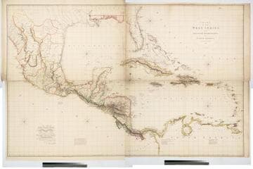
Chart of the West Indies and Spanish Dominions in North America. By A. Arrowsmith 1803
Visual Materials
Kashnor notes, "Amongst other interesting particulars, this map indicates the positions of the canals proposed to be cut by the Spaniards in 1528. The original issue of Arrowsmith's map, valuable for the detail regarding the coast of present-day Texas and the colonies of New Santander." " Jones Smith & Co. sc. Beaufort Build'gs Strand." "To Admiral John Willett Payne, A distinguished Native of the West Indies. Vice Admiral of the Coasts of Devonshire & Cornwall, Treasurer of Greenwich Hospital, Comptroller General of the Household of the Prince, &c., &c., &c. This chart is respectfully Dedicated by his most obedient Serv't A. Arrowsmith." Prime meridian: London. Relief: hachures. Projection: Cylindrical. Printing Process: Copper engraving. Verso Text: MS note: 795.
105:795 M
Image not available
A Chart of the Banks of Newfoundland, Drawn from a Great Number of Hydrographical Surveys
Visual Materials
"[Drawn] chiefly from those of Chabert, Cook and Fleurieu, Connected and Ascertained by Astronomical Observations." Tracks voyages of Fleurieu, Chabert and Cook. A later issue of map 105:548 with extended western coverage. Note ships have been redrawn, astronomical chart redrawn. Prime meridian: London. Relief: no. Graphic Scale: Leagues. Projection: Mercator. Printing Process: Copper engraving. Verso Text: MS notes: 549 .
105:549 M