Visual Materials
A Mapp of Newfoundland, by John Seller, at the Hermitage in Wapping, London

You might also be interested in
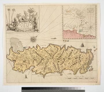
Island of Tobago by John Seller And are to be Sold at his Shop on the West side of the Royall Exchange And at the Hermitage in Wapping
Visual Materials
Kashnor dates as ca. 1680. Cartouche: Natives and animals. Submap: Cgart of the Carriby-Islands.. Relief: pictorial. Graphic Scale: Miles. Projection: Cylindrical. Printing Process: Copper engraving. Other Features: CartoucheSub-maps. Verso Text: MS note: 834.
093:834 M
Image not available
A Chart of the Northernmost part of America by Jer:Seller & Cha:Price at the Hermitage in Wapping
Visual Materials
Kashnor notes, "The map is founded upon that of Captain Thomas Lane's. The East Main and Labrador are shown as Prince Rupert's Land and New Brittaine, and the west side of the Bay bears the names of New Yorkshire and New South Wales. Evidentally issued soon after the formation of the Hudson's Bay Company." Kashnor dates as [1675]. Lower right corner torn and repaired.. Relief: no. Graphic Scale: Leagues, Miles. Projection: Cylindrical. Printing Process: Copper engraving. Verso Text: MS notes: 437 C3.
105:437 M
Image not available
Chart of the North Part of America, describing the Sea Coast of Groenland, Davies Streights, Baffins Bay, Hudsons Bay, Buttons Bay, and James Bay, by John Seller, Hydrographer to the King at the Hermitage in Wapping London
Visual Materials
Kashnor notes, "The map of Hudson's Bay follows that of Captain Thomas James. The East Main and Labrador are known as Prince Rupert's Land and New Brittaine, and the west side of the Bay bears the names of New Yorkshire and New South Wales. Evidently issued soon after the formation of the Hudson's Bay Company." Submap shows "A Polar Projection of the Northernmost Parts of the World." Kashnor dates [1675]. Hand colored cartouche with natives. Polar projection submap with fruit embellishment. MS notes: Hudsons Streights. Capt Thomas James wintered at this Isle Charleston in the year 1632.. Relief: no. Graphic Scale: leagues. Projection: Cylindrical. Watermark: lettering device. Printing Process: Copper engraving. Other Features: CartoucheSub-maps. Verso Text: MS note: 232.
093:232 M

A New Map of the West Indies; or the Islands of America in the North Sea
Visual Materials
Kashnor notes, :Shows the coast of present-day Texas, and locates the Acansa and Teaucas Land, 'The People about this river are continually in Wars with the Spaniards'." Four harbor submaps. Submaps: A Draught of the Bay & City of Havana; The Bay of Porto Bella; A Draught of the Sity of Cartogena, its Harbour & Forts; La Vara Cruz. Cartouche: Soldiers, battle.. " With the Adjacent Parts, Explaining what belongs to England, Holland, Spain, France, &c. Also the Several Tracts made by the Gallions and Flota. by N. Vischer of Amsterdam. Is now done into English with many Considerable improvements according to the Newest and Best Observations." Prime meridian: Ferro. Relief: pictorial. Graphic Scale: Miles, leagues. Projection: Cylindrical. Printing Process: Copper engraving. Other Features: Sub-mapsCartouche.
105:800 M

Plan of the Island of St. John with the divisions of the Counties Parishes & the Lots as granted by Government likewise the Soundings round the Coast and Harbours
Visual Materials
Kashnor notes, "This is the first issue of Holand's map before it passed to Sayer and Bennett." Submap: Gulf of St. Laurence. Table: the Contents of the Respective Divisions of the Island of St. John. Cartouche: Fishing, farming view.. "Surveyed by Capt. Holland 1775." Prime meridian: London. Relief: no. Graphic Scale: Miles. Projection: Plane. Watermark: Crowned fleur-di-lis WF. Printing Process: Copper engraving. Other Features: Sub-mapsCartouche. Verso Text: MS notes: 754 4.
105:754 M
Image not available
A Mapp of New Jersey in America / by John Seller and William Fisher
Rare Books
Accompanying notes from John Carter Brown Library regarding map and its reproduction. "A facsimile of the original map in the John Carter Brown Library, Brown University, Providence, Rhode Island." Prime meridian: Gm. Relief: pictorial. Graphic Scale: Leagues. Projection: Cylindrical. Printing Process: Lithography.
325067