Visual Materials
Chart of the North Part of America, describing the Sea Coast of Groenland, Davies Streights, Baffins Bay, Hudsons Bay, Buttons Bay, and James Bay, by John Seller, Hydrographer to the King at the Hermitage in Wapping London
You might also be interested in
Image not available
A Chart of the Northernmost part of America by Jer:Seller & Cha:Price at the Hermitage in Wapping
Visual Materials
Kashnor notes, "The map is founded upon that of Captain Thomas Lane's. The East Main and Labrador are shown as Prince Rupert's Land and New Brittaine, and the west side of the Bay bears the names of New Yorkshire and New South Wales. Evidentally issued soon after the formation of the Hudson's Bay Company." Kashnor dates as [1675]. Lower right corner torn and repaired.. Relief: no. Graphic Scale: Leagues, Miles. Projection: Cylindrical. Printing Process: Copper engraving. Verso Text: MS notes: 437 C3.
105:437 M
Image not available
Chart of the North Part of America, For Hudson's Bay commonly called NorthWest Passage
Visual Materials
Kashnor notes, "Thornton's chart of Hudson's Bay is said to be the earliest published. The soundings were supplied by the captains of the Hudson's Bay Company, probably by Gillam and Stannard. Port Nelson, Rupert's River, 'Moesche' River, Peter's River, East Maine, Little Creek and Frenchman River are all located." Royal coat of arms center. Cartouche of Indians and victims(?) MS note: 233. Relief: no. Graphic Scale: Leagues, miles. Projection: Cylindrical. Printing Process: Copper engraving. Other Features: Art WorkCartouche. Verso Text: MS note: 233.
093:233 M
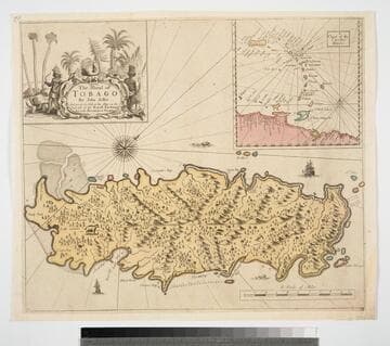
Island of Tobago by John Seller And are to be Sold at his Shop on the West side of the Royall Exchange And at the Hermitage in Wapping
Visual Materials
Kashnor dates as ca. 1680. Cartouche: Natives and animals. Submap: Cgart of the Carriby-Islands.. Relief: pictorial. Graphic Scale: Miles. Projection: Cylindrical. Printing Process: Copper engraving. Other Features: CartoucheSub-maps. Verso Text: MS note: 834.
093:834 M
Image not available
A New and Correct Chart of the North Part of America from New Found Land to Hudson's Bay
Visual Materials
Kashnor notes, "A very good map of Hudson's Bay, showing a great number of locations. Shows York Fort, but no forts on Albany or Moose River, or at New Severn." Rather crude figures around cartouche.. Prime meridian: Lizard. Relief: no. Projection: Cylindrical. Printing Process: Copper engraving. Other Features: Cartouche. Verso Text: MS note: 447.
105:447 M

Chart of the Atlantic Ocean, with the British, French & Spanish Settlements in North America and the West Indies; as also on the Coast of Africa
Visual Materials
Kashnor notes, "Shows the old boundaries of Carolina and Virginia, with the coast from Hudson's Straits to the Amazon." Shows false "New Discovered Sea" east of Hudson's Bay. Latitude and longitude observations from several sources compared in tabular form. Kashnor dates as [1775]. Latitude and longitude tables.. Prime meridian: Ferro. Relief: pictorial. Projection: Mercator. Printing Process: Copper engraving. Verso Text: MS note: 161.
105:161 M
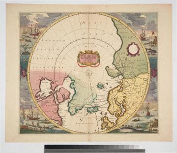
Poli Arctici, et circumiacentium terrarum descriptio novissima / per F. de Wit
Visual Materials
Kashnor notes, "Shows Hudson's Bay before the advent of the Company. The map followed that given by Capt. Thomas James." Kashnor dates as "c. 1670." Canadian archives date map to 1715. Whaling and sealing scenes each corner, beautifully colored. Prime meridian: Ferro. Relief: no. Projection: Polar. Printing Process: Copper engraving. Verso Text: MS notes: 242 C16u.
093:242 M