Manuscripts
Exhibit A: Plat of a Part of the Rancho Paso de Bartolo conveyed to Eli W. Hawkins by Juaquna [sic] and Trenidad [sic] Moreno

You might also be interested in
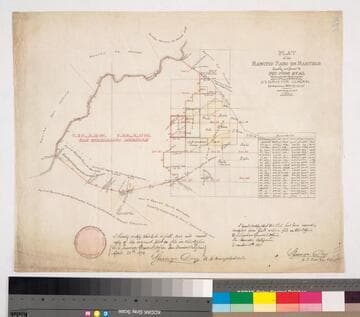
Plat of the Rancho Paso de Bartolo finally confirmed to Pio Pico et al
Manuscripts
Bordered by Ranchos Santa Gertrudes, San Antonio, La Merced, Potrero de Felipe Lugo, La Puente, San Gabriel River. Copy certified by Sherman Day, Surveyor General; Var. 15° 30' East. Inset with table of boundaries. T.2S. R.12W., T.2S. R.11W. S.B.M.
mssSolano SR_Map_0097

Plat of the Rancho Paso de Bartolo finally confirmed to Pio Pico
Manuscripts
Bordered by Ranchos Santa Gertrudes, San Antonio, La Merced, Potrero de Felipe Lugo, La Puente and public lands. Shows section numbers, surface details, parcel owners, structures, markers, acreage; color highlighting; has table with boundary data. Alt. title supplied by cataloger.
mssSolano SR_Box_22(06).05
![Plat of the Rancho Los Cierritos [Cerritos] finally confirmed to Juan Temple](/_next/image?url=https%3A%2F%2Frail.huntington.org%2FIIIF3%2FImage%2F22APN4KPHI01%2Ffull%2F%5E360%2C%2F0%2Fdefault.jpg&w=750&q=75)
Plat of the Rancho Los Cierritos [Cerritos] finally confirmed to Juan Temple
Manuscripts
Bordered by Ranchos Los Alamitos, San Pedro, Los Coyotes, Santa Gertrudes; Pacific Ocean. Inset with extensive table of boundaries. Color highlights; hachures; San Gabriel River; Juan Temple's house indicated, 22194 35/100 acres. Var. 13° 30' E.
mssSolano SR_Map_0037
Image not available
Plat of a Part of the Rancho Paso de Bartolo conveyed to Eli W. Hawkins
Manuscripts
The collection consists of maps, field books, legal documents, business papers, and diaries related to the work of surveyors George Hansen, Alfred Solano, Sidney B. Reeve, and others. The maps and surveys in the collection are of the city of Los Angeles, Southern California ranchos, and subdivisions of the city of Los Angeles and neighboring towns. The collection contains over maps and sketch maps. Other subjects represented in the collection include: civil engineering, land subdivision, mines and mineral resources, and daily life in Los Angeles and Los Angeles County.
mssSolano

Paso Bartolo
Manuscripts
Bordered by San Gabriel River; Rancho Santa Gertrudes. Diseño line in blue; requested by Pio Pico (indicated on map). Sketch map on back 1:20 chains, ink with pencil annotations, coordinates.
mssSolano SR_Map_0094

Rancho Paso de Bartolo: southern half
Manuscripts
San Gabriel River on the west (?) side. Bordered by Rancho Santa Gertrudes. Var. 13° 30'. Case No. L.r. 77 stamp dated Jan. 29, 1917. Numerous landowners indicated including Pio Pico estate. Waterways in blue; hachures, land features. Title supplied by cataloger.
mssSolano SR_Map_0093.01