Manuscripts
El Potrero or Irrigable Flat of the Rancho Los Feliz

You might also be interested in

El Potrero or Irrigable Flat of the Rancho Los Feliz
Manuscripts
Showing part described in deed from Leon Mc L. Baldwin to John M. Baldwin Aug. 11, 1871. T.1N. R.13W. ; Var. 14° 30' E.. Table bottom & Hills. Alternate title supplied by cataloger.
mssSolano SR_Map_0070.02

Rancho de los Felis: division-line.; Coronel and Lick properties
Manuscripts
T.1N. R.13W.; inset table with courses, bearings. Boundary landmarks indicated. Title supplied by cataloger.
mssSolano SR_Map_0069

Map Showing the Land in the Rancho Los Feliz planted to Alfalfa by Richardson
Manuscripts
Bordered by Rancho San Rafael, Glassell property & Los Angeles River Color highlights, hachures, fences; Var.14° 30' East Requested by W. L. Wills
mssSolano SR_Map_0080
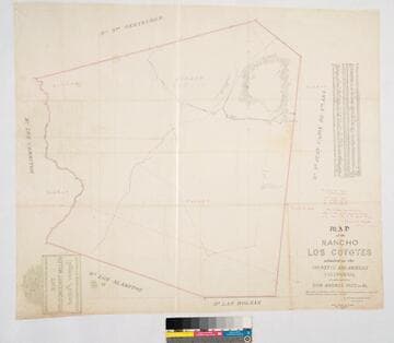
Map of the Rancho Los Coyotes
Manuscripts
Bordered by Ranchos San Juan Cajon de Santa Ana, Las Bolsas, Los Alamitos, Los Cerritos, Santa Gertrudes. Hachures & color highlights. Inset with table of coordinates. Confirmed to don Andres Pico, et al.. Var. 13° 30' E. Jan 22, 1861, divisions by Wm. H. Leighton
mssSolano SR_Map_0050
![Plat of the Rancho Los Cierritos [Cerritos] finally confirmed to Juan Temple](/_next/image?url=https%3A%2F%2Frail.huntington.org%2FIIIF3%2FImage%2F22APN4KPHI01%2Ffull%2F%5E360%2C%2F0%2Fdefault.jpg&w=750&q=75)
Plat of the Rancho Los Cierritos [Cerritos] finally confirmed to Juan Temple
Manuscripts
Bordered by Ranchos Los Alamitos, San Pedro, Los Coyotes, Santa Gertrudes; Pacific Ocean. Inset with extensive table of boundaries. Color highlights; hachures; San Gabriel River; Juan Temple's house indicated, 22194 35/100 acres. Var. 13° 30' E.
mssSolano SR_Map_0037

Rancho Los Alamitos owned by Don Abel Stearns
Manuscripts
Bordered by the Pacific Ocean, Rancho Los Sierritos [Cerritos], Rancho Bolsa Chica,. Rancho Los Coyotes. [Map must be after February 23, 1857 when district court affirmed the claim.]. Inset of table listing distances. Magnetic Meridian Var. 13° 30' east. T. 4 S.R. 11 W.. T. 5 S.R. 11 W.. T. 4 S.R. 12 W.. Color highlights. Includes wetlands and waterways, hachures. Originally granted to Don Juan Jose Nieto by Governor Jose Figueroa 1833
mssSolano SR_Map_0005