Manuscripts
Map Showing the Land in the Rancho Los Feliz planted to Alfalfa by Richardson

You might also be interested in

Survey of the W.L. Wills Tract
Manuscripts
Bordered by Rancho San Rafael (NW?). Color highlights, hachures, wire fences; var. 14° 30' East. Other property owners indicated: Richardson, Glassell, Pollock, J. W. Potts, Spencer Wilson. Alternate title supplied by cataloger.
mssSolano SR_Map_0079
![[Ranchos Providencia and Cahuenga: boundary map]](/_next/image?url=https%3A%2F%2Frail.huntington.org%2FIIIF3%2FImage%2F22APN4KCF8OS%2Ffull%2F%5E360%2C%2F0%2Fdefault.jpg&w=750&q=75)
[Ranchos Providencia and Cahuenga: boundary map]
Manuscripts
Bordered by Ranchos San Rafael, San Fernando.T.1N. R.14W. on back of map. Hachures, color highlights; features include Cahuenga Pass, Los Angeles River, fences and structures. Rancho San Rafael confirmed to Julio & Catalina Berdugo [Verdugo]. Title supplied by cataloger.
mssSolano SR_Map_0113
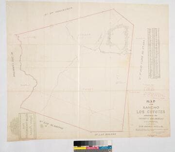
Map of the Rancho Los Coyotes
Manuscripts
Bordered by Ranchos San Juan Cajon de Santa Ana, Las Bolsas, Los Alamitos, Los Cerritos, Santa Gertrudes. Hachures & color highlights. Inset with table of coordinates. Confirmed to don Andres Pico, et al.. Var. 13° 30' E. Jan 22, 1861, divisions by Wm. H. Leighton
mssSolano SR_Map_0050

Rancho Los Alamitos owned by Don Abel Stearns
Manuscripts
Bordered by the Pacific Ocean, Rancho Los Sierritos [Cerritos], Rancho Bolsa Chica,. Rancho Los Coyotes. [Map must be after February 23, 1857 when district court affirmed the claim.]. Inset of table listing distances. Magnetic Meridian Var. 13° 30' east. T. 4 S.R. 11 W.. T. 5 S.R. 11 W.. T. 4 S.R. 12 W.. Color highlights. Includes wetlands and waterways, hachures. Originally granted to Don Juan Jose Nieto by Governor Jose Figueroa 1833
mssSolano SR_Map_0005
![Plat of the Rancho Los Cierritos [Cerritos] finally confirmed to Juan Temple](/_next/image?url=https%3A%2F%2Frail.huntington.org%2FIIIF3%2FImage%2F22APN4KPHI01%2Ffull%2F%5E360%2C%2F0%2Fdefault.jpg&w=750&q=75)
Plat of the Rancho Los Cierritos [Cerritos] finally confirmed to Juan Temple
Manuscripts
Bordered by Ranchos Los Alamitos, San Pedro, Los Coyotes, Santa Gertrudes; Pacific Ocean. Inset with extensive table of boundaries. Color highlights; hachures; San Gabriel River; Juan Temple's house indicated, 22194 35/100 acres. Var. 13° 30' E.
mssSolano SR_Map_0037

Map of that part of the Rancho Paso de Bartolo in the County of Los Angeles showing the partition.;(Map A)
Manuscripts
Bordered by Ranchos San Antonio, Rancho La Merced, Potrero de Felipe Lugo, La Puente, Town of Whittier. Referees in partition Alfred Solano, John E. Jackson, Thomas E. Rowan decreed by LA Superior Court Dec 27, 1893. Color highlights, hachures, landowners, roadways (Workman Mill Road), waterways indicated.
mssSolano SR_Map_0106.01