Manuscripts
Map of the Tracts of the Land No. 1 & 2 of the allotment of Andrés, José Antonio, Rafael & Cristobal Machado in the Rancho La Ballona in the County of Los Angeles Cal

You might also be interested in

Map of the Tracts of the Land No. 1 & 2 of the allotment of Andrés, José Antonio, Rafael & Cristobal Machado in the Rancho La Ballona in the County of Los Angeles Cal
Manuscripts
Rancho La Ballona. Showing the subdivision made by Manuel F. Coronel, A. W. Htton, Arbitrators; survey made under the direction of arbitrators. True courses; variation of magnetic needle 14°45 E. 7 insets: tables for Partition of Tracts 1& 2, for Machado family members, with coordinates and distances.
mssSolano SR_Map_0013.02

Map of the Tract No. 4 of the Allotment of Andres, José Antonio, Rafael & Cristobal Machado in the Rancho "La Ballona"
Manuscripts
Pacific Ocean. Bordering Rancho San Vicente. Rancho La Ballona. Subdivision with names of tract owners (Machado family), with tables of courses. Hachures in pencil; coordinates. Showing the Subdivision by Manuel F. Coronel, A. W. Hutton, arbitrators. Survey made under the direction of the arbitrators. Variation 14° 45' E
mssSolano SR_Map_0015.01

Map of the Tract No. 4 of the Allotment of Andres, José Antonio, Rafael & Cristobal Machado in the Rancho "La Ballona"
Manuscripts
Pacific Ocean. Bordering Rancho San Vicente. Rancho La Ballona. Subdivision with names of tract owners (Machado family), with tables of courses. Hachures & color highlights; coordinates. Showing the Subdivision by Manuel F. Coronel, A. W. Hutton, arbitrators. Survey made under the direction of the arbitrators. Variation 14° 45' E
mssSolano SR_Map_0015.02

Map of the Tract of Land No. 3 of the Allotment of Andres, José Antonio, Rafael & Cristobal Machado and of the 120 acre tract of Ygnacio Machado in the Rancho La Ballona
Manuscripts
Rancho La Ballona. Color highlights; adjacent parcels belonging to Young, Talamantes & Sanford families. Showing the Subdivision by Manuel F. Coronel, A. W. Hutton, arbitrators. Survey made under the direction of the arbitrators. Var. of the mag. needle 14° 45' E. Inset with tables featuring 7 Machado family members with coordinates & distances.
mssSolano SR_Map_0014
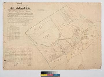
Map of the Rancho "La Ballona"
Manuscripts
Bordered by Pacific Ocean. Ballona Partition containing 13919.90 acres according to survey made by (L. Seebold for Hansen), under instructions from H. Hancock, July, 1858 showing partition made by J.J. Warner, H. Thomas & E. H. Boyd. Variation 14°15' E.. Inset with table listing partitions, names & land data. Inset with table listing boundary coordinates & distances. Machado (Young, Sanford, et al) family members are referenced on the partitions with acreage. "La Ballona Grant confirmee A. Machado, et al, patented December 8, 1873".
mssSolano SR_Map_0012.01

Map of the Rancho "La Ballona"
Manuscripts
Bordered by Pacific Ocean. Variation 14°15' E.. Ballona Partition containing 13919.90 acres according to survey made by under instructions from H. Hancock, July, 1858 showing partition made by J.J. Warner, H. Thomas & E. H. Boyd (signed by L. Seebold for Hansen). Machado (Young, Sanford, et al) family members are referenced on the partitions with acreage. Inset with table listing partitions, names & land data. Inset with table listing boundary coordinates & distances.
mssSolano SR_Map_0012.02