Manuscripts
Rancho El Encino
You might also be interested in

Rancho El Encino
Manuscripts
Map within document: "Rancho El Encino finally confirmed to Vicente de la Osa..." fourth page - showing townships, lot numbers, surface details, markers, distances; Los Angeles River, Road to San Fernando. Title supplied by cataloger.
mssSolano SR_Box_21(07).01
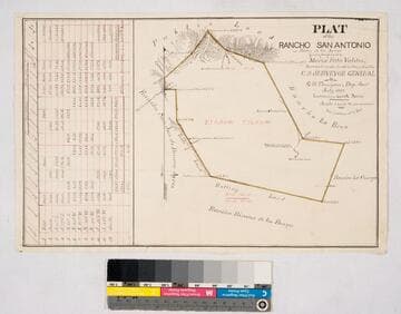
Plat of the Rancho San Antonio or Rodeo de las Aguas
Manuscripts
Bordered by Ranchos La Brea, San Jose de Buenos Ayres, Rincon de los Bueyes, La Cienega and public land. Hachures, land features, structures. Finally confirmed to Maria Rita Valdez. Table inset with courses, distances, acres.
mssSolano SR_Map_0132

Rancho El Conejo
Manuscripts
Pacific Ocean. Santa Susanna Mountains. Color highlights, hachures; land features. Section of sheet cut away; inset of table with Meanders of Pacific Ocean. Ranchos Conejo & Simi finally confirmed to José de la Guerra y Noriega; El Escorpion Tract confirmed to Indian Urbano & others. Sierra del Potrero. Rancho Las Virgenes very faint [erased?] Alternate title supplied by cataloger.
mssSolano SR_Map_0049

Plat of the Rancho San José del Valle
Manuscripts
"High hills" and "Mountains" indicated on southern border. Red & black ink, hachures, land & structure features. Finally confirmed to Juan Jose Warner, containing 26,629 acres; certified by J. W. Mandeville - plat and approval, Sept 27-Oct 20, 1860; field notes, March 3, 1860. Inset with table of courses, boundary data
mssSolano SR_Map_0164

Plat of the Rancho San José de Buenos Ayres
Manuscripts
Bordered by Ranchos San Antonio or Rodeo de Las Aguas, Rincon de los Bueyes, La Ballona, San Vicente; coast range of mountains. T. 1S. R. 15W. Lot No. 38. Finally confirmed to Benjamin D. Wilson. Inset: table with boundary data; Var. 13° 30' East. Faded color highlighting; dense hachures. Field notes on file as of July 2nd, 1859
mssSolano SR_Map_0162

Rancho Paso de Bartolo : S62 no. 1 - road through part of Rancho Paso de Bartolo
Manuscripts
Map within document: "...intersect the division line between Standefer and . Dunlap to the South and Pico to the North..." eighth page in; shows road with courses, distances, adjacent property owners (Cate, Dunlap, Pico, Verdugo, Sanchez, Aguirre), San Gabriel River, hachures, ditch. Title supplied by cataloger.
mssSolano SR_Box_22(07).13