Manuscripts
Plat of the Rancho San José de Buenos Ayres

You might also be interested in
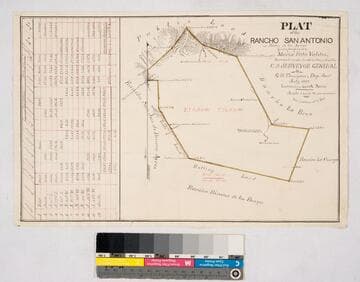
Plat of the Rancho San Antonio or Rodeo de las Aguas
Manuscripts
Bordered by Ranchos La Brea, San Jose de Buenos Ayres, Rincon de los Bueyes, La Cienega and public land. Hachures, land features, structures. Finally confirmed to Maria Rita Valdez. Table inset with courses, distances, acres.
mssSolano SR_Map_0132
Plat of the ex Mission of San Fernando
Manuscripts
Bordered by Santa Susana Mtns., Sierra Madre or San Fernando Mtn., Tujunga Rancho, Rancho San Rafael, Providenicia y Cahuenga, High Rough Mtn., Rancho Las Virgenes. Finally confirmed to Eulogio de Celis . . . Var. 13° 30' East. Inset of table with courses & distances.
mssSolano SR_Map_0141
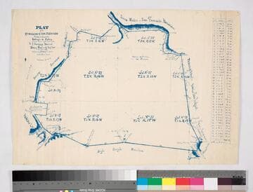
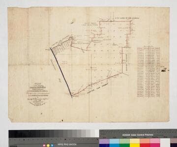
Plat of Rancho Rodeo de las Aguas
Manuscripts
Bordered by Ranchos Rincon de los Bueyes, La Cienega, La Brea. Hachures, land features, structures. Title supplied by cataloger.
mssSolano SR_Map_0133

Plat of the Santiago de Santa Ana Rancho
Manuscripts
Bordered by ranchos El Cajon de San Juan, Cajon de Santa Ana, Bolsas, San Joaquin, and the Pacific Ocean. Original survey: 1857 Nov & Dec.; copy confirmed by J. W. Mandeville to Bernardo Yorba et al.. Inset with table of boundary data. Color highlights, detailed hachures, structures, water bodies including Santa Ana River, structures, rugged mountains.
mssSolano SR_Map_0254
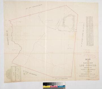
Map of the Rancho Los Coyotes
Manuscripts
Bordered by Ranchos San Juan Cajon de Santa Ana, Las Bolsas, Los Alamitos, Los Cerritos, Santa Gertrudes. Hachures & color highlights. Inset with table of coordinates. Confirmed to don Andres Pico, et al.. Var. 13° 30' E. Jan 22, 1861, divisions by Wm. H. Leighton
mssSolano SR_Map_0050
Plat of the Rancho Sausal Redondo
Manuscripts
Bordered by Shoalwater Bay, ranchos La Ballona, Cienega o Paso de la Tijera, Aguaje de la Centinela, San Pedro, Tajauta, public lands, and Los Angeles City lands. Finally confirmed to Antonio Ignacio Abila Containing 48750 02/100 Acres. Color highlighting, section numbers. Inset with table of boundary data.
mssSolano SR_Map_0260