Manuscripts
Plat of the Santiago de Santa Ana Rancho

You might also be interested in

Map of the Rancho Santiago de Santa Ana
Manuscripts
Pacific Ocean at bottom, Rancho Las Bolsas to the west. Parcel owners include A. Glassell, E. Polloreno, Benjamin & Thomas Flint. Detailed hachures, colored highlights, structures, topographical features, vegetation. Southern Line of Mustard. Verso: Ro. Santiago de Santa Ana.
mssSolano SR_Map_0256.01B
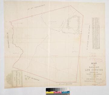
Map of the Rancho Los Coyotes
Manuscripts
Bordered by Ranchos San Juan Cajon de Santa Ana, Las Bolsas, Los Alamitos, Los Cerritos, Santa Gertrudes. Hachures & color highlights. Inset with table of coordinates. Confirmed to don Andres Pico, et al.. Var. 13° 30' E. Jan 22, 1861, divisions by Wm. H. Leighton
mssSolano SR_Map_0050

Map of the Rancho Santiago de Santa Ana
Manuscripts
Cajon de San Juan to the west. Parcel owners include Heirs of Leandro Peralta; Van de Graff, Serrano, T. D. Mott, Asencion Sepulveda. Detailed hachures, colored highlights, structures, topographical features, vegetation.
mssSolano SR_Map_0256.01H

Rancho Cajon de Santa Ana
Manuscripts
Rancho San Juan Cajon de Santa Ana . Boundaries outlined in color; coordinates. . Alt title supplied by cataloger.
mssSolano SR_Map_0165

Map of the Rancho Santiago de Santa Ana
Manuscripts
Bordered by Rancho Las Bolsas to the west. Parcel owners include James McFadden, F. W. Koll, Asencion Sepulveda, Jacob Ross. Detailed hachures, colored highlights, structures, topographical features, vegetation.
mssSolano SR_Map_0256.01C
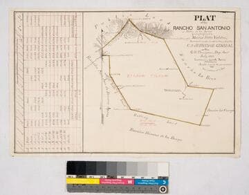
Plat of the Rancho San Antonio or Rodeo de las Aguas
Manuscripts
Bordered by Ranchos La Brea, San Jose de Buenos Ayres, Rincon de los Bueyes, La Cienega and public land. Hachures, land features, structures. Finally confirmed to Maria Rita Valdez. Table inset with courses, distances, acres.
mssSolano SR_Map_0132