Opening Hours
Daily: 10 A.M.–5 P.M.
Closed on Tuesdays
1151 Oxford Road
San Marino, CA 91108
Daily: 10 A.M.–5 P.M.
Closed on Tuesdays
1151 Oxford Road
San Marino, CA 91108

Visual Materials
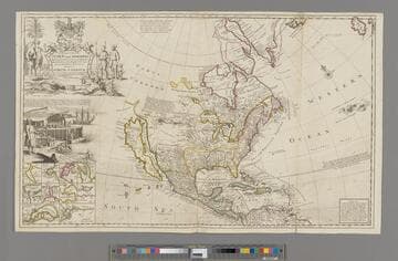
Kashnor notes,"Shows a good map of the Far West, according to knowledge at the time particularly of New Mexico. California is still an island and there is a river which is in the locality of the Columbia." Map includes famous fish drying vignette, and is known as the "Cod Fish" map. McLaughlin dates as 1719. Note this is probably an earlier state, missing John King from map sellers mentioned by McLaughlin. Cartouche: Indians & Eskimos, Moll armorial. Fish drying vignette. Submaps: St John's Harbour, Boston Harbour, New York Harbour, Charlestown Harbour, Port Royal Harbour, Havana Harbour, Pto. Bello Harbour, La Vera Cruz, Cartagena Harbour, Port of Acapulco. . Prime meridian: London. Relief: pictorial. Projection: Azimuthal. Printing Process: Copper engraving. Other Features: CartoucheVignettesSub-maps. References: McLaughlin 192; Wagner 514; Wheat 105; Tooley 82; Leighly 145; Stevens No. 7; Goss 53 (plate).. Verso Text: MS notes: No. 7 G D 213.
093:213 M
Image not available
Visual Materials
Kashnor notes, "This issue shows the same Oregon and Russian-American boundaries, but it also shows the new boundaries which include Texas, New Mexico and Upper California as within the territory of the United States." Kashnor dates as ca. 1847. See also 093:556 for an earlier version of this map. Prime meridian: GM. Relief: hachures. Projection: Azimuthal. Printing Process: Engraving. Verso Text: MS note: 557.
093:557 M
Image not available
Visual Materials
Kashnor notes, "Shows the Illinois country and Hennepin's route, with the old trading route to Aiaouex, locating the town somewhere in the neighborhood of the present Iowa State at Sioux City." Subview of beavers copied from Moll. Distorted idea of a buffalo. Kashnor dates as ca. 1720. View of Niagara Falls copied from Moll. Cartouche with priest and native. Indians with "buffalo" looking more cowlike than bison. Prime meridian: Ferro. Relief: pictorial. Graphic Scale: Miles, Leagues. Projection: Cylindrical. Printing Process: Copper engraving. Verso Text: MS note: 416.
093:416 M
Image not available
Visual Materials
Kashnor notes, "Shows all the American Continent, with the North-West Coast reaching above California, which is represented as an island." On North America, "This Continent with the adjoining Islands is generally supposed to have been Anciently unknown thought there are not wanting some, who will have even the Continent its self to be no other than the Insula Atlantis of the Ancients." Kashnor dates as 1698, Shirley dates 1700-01. This is the first world map in Wells' atlas, see 105:270 for another copy. 093:198M is the second similar map from the same atlas, per Shirley. Cartouche of Britannia and coat-of-arms. Vignette of Radcliffe Camera of Oxford, student and teacher, sailing ships at new lands. . Prime meridian: London. Relief: no. Graphic Scale: No. Projection: Dual Hemisphere. Printing Process: Copper engraving. Other Features: CartoucheVignettes. References: Shirley 608, BM Maps, Vol. 15, col 33 38e.1; Phillips 531; Wagner 467.. Verso Text: Ms. 47.
093:047 M
Image not available
Visual Materials
Kashnor notes, "Shows New Netherland, showing "Nieu Amsterdam ofte nieu Yorck," New London, Long Island, "Noorte Rivier" and Boston ; also shows Newfoundland, New France, part of the West Indies and South America." Kashnor dates as [1695]. Cartouche: colored w. putti and atlas.. Prime meridian: Teneriffe. Relief: no. Projection: Cylindrical. Printing Process: Copper engraving. Other Features: Cartouche. Verso Text: MS note: 501.
093:501 M
Visual Materials
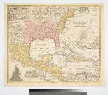
Kashnor notes, "Gives a good map of New Mexico, locating Santa Fe and Taos; also shows the old boundaries of Louisiana." Kashnor dates as ca. 1730. Derived from L'Isle map. See 105:470M for another copy. This copy shows reworking of cartouche and illustrations, seemingly a later copy than 105:470M. Vignettes: Sea battle; Merchants & Indians. Prime meridian: Ferro. Relief: pictorial. Graphic Scale: Miles. Projection: Pseudocylindrical. Printing Process: Copper engraving. Verso Text: MS note: 470.
093:470 M