Visual Materials
Map of Kentucky Drawn from Actual Observations by John Filson
You might also be interested in
Image not available
Map of the Eastern Townships of Lower Canada, Drawn principally from actual Survey for the British American Land Company, by A. Wells, Provincial Land Survr
Visual Materials
Kashnor notes, " Shows the enormous tracts of land held by the Company." [Each parcel hand colored.] Inset plan of Quebec City. Submap: Plan of Quebec [City]. Prime meridian: GM. Relief: hachures. Graphic Scale: Miles, leagues. Projection: Cylindrical. Printing Process: Engraving. Other Features: Sub-maps. Verso Text: MS notes: 2 sheets 350.
093:350 M
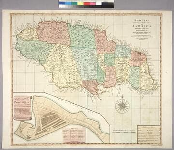
Bowles's New One-Sheet Map of Jamaica, Divided into its Parishes, &c. from the Actual Surveys of Sheffield and others
Visual Materials
Submap: General plan of Port Royal [showing before and after earthquake dimensions].. Prime meridian: London. Relief: pictorial. Graphic Scale: Miles. Projection: Cylindrical. Printing Process: Copper engraving. Other Features: Sub-maps. Verso Text: MS note: 788.
093:788 M
Image not available
A New Map of Carolina
Visual Materials
Kashnor notes, "An important map, showing the exact state of the settlements in Carolina at the close of the XVII century. The inset map of Ashley River shows the names and locations of thirty-seven settlers." Kashnor dates as ca. 1680. Submap: A particular map for going into Ashley and Cooper Rivers. Table lists 33 settlers.. Prime meridian: London. Relief: pictorial. Graphic Scale: Miles. Projection: Cylindrical. Watermark: KO?. Printing Process: Copper engraving. Other Features: Sub-maps. Verso Text: MS notes: 96 105:336.
105:336 M
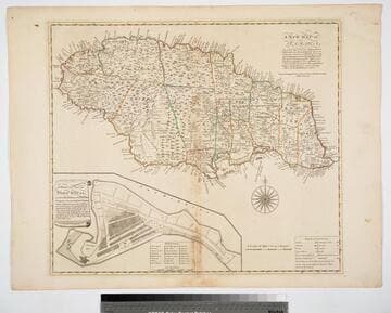
New Map of Jamaica In which the Several Towns Forts & Settlements are Accurately laid down, as well as the situations & depths of the most noted Harbours and Anchoring Places, with the limits and boundaries of the different Parishes, as they have been regulated by Law, or settled by Custom, the greatest part Drawn or Corrected from actual Surveys Made by Mr. Sheffield and others
Visual Materials
Submap: General Plan of Port Royal in which Different States of the Town are Accurately laid Down. . Prime meridian: London. Relief: pictorial. Graphic Scale: Miles. Projection: Cylindrical. Watermark: Crowned fleur-di-lis IV. Printing Process: Copper engraving. Other Features: Sub-maps. Verso Text: MS notes: 801 J5..
093:801 M

St. Lucia; Done from Surveys and Observations made by the English whilst in their Possession. by Thomad Jefferys Geographer to the King. Published by Laurie & Whittle, No. 53 Fleet Street London as the Act directs 12th May, 1794
Visual Materials
Submap: Plan of Carenage.. Prime meridian: London. Relief: hachures. Graphic Scale: Leagues. Projection: Cylindrical. Printing Process: Copper engraving. Other Features: Sub-maps.
093:830 M
Image not available
Map of Louisiana, from D'Anville's Atlas
Visual Materials
Kashynor notes, " The inset map shows the Mississippi River to the junctions with the Missouri and Illinois Rivers." Submsp: Upper Louisiana. Relief: pictorial. Graphic Scale: Leagues. Projection: Cylindrical. Printing Process: Copper engraving. Other Features: Sub-maps.
105:483 S