Rare Books
A New Map of North America from the Latest Discoveries 1763
You might also be interested in
Image not available
A New Map of North America from the Latest Discoveries 1763.A New Map of North America from the Latest Discoveries 1763
Rare Books
See 130449 for another copy of this map. Note the cartouche has been revised one to the other. Maine border extended further north by coloring on this map. Cartouche: more elaborate than 130449. MS note: 130450. Prime meridian: London. Relief: pictorial. Projection: Cylindrical. Watermark: Two crowned circular devices. Printing Process: Copper engraving. Other Features: Cartouche.
130450
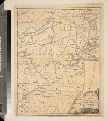
New and Accurate Map of the Present Seat of War in North America, Comprehending New Jersey, Philadelphia, Pensylvania (sic), New-York &c
Visual Materials
Kashnor dates as c.1770. Probably later because of reference to Revolutionary War. Some notes regarding boundary dispute between New York and New Jersey. Small vined cartouche with sailing ship. MS note: 101 (on backing). Prime meridian: London. Relief: pictorial. Graphic Scale: Miles, statute. Projection: Cylindrical. Watermark: Crowned seal. Printing Process: Copper engraving. Other Features: Cartouche. Verso Text: MS note: 410 (map) 101 (on backing).
093:101 S
Image not available
A New Map of North America from the Latest Discoveries. 1763
Visual Materials
Kashnor notes, "A good map of the far west to the Lake of the Woods, and locating Fort St. Charles and Fort St. Pierre. Shows the old boundaries of Carolina, Virginia, and New England reaching beyond the Mississippi." MS note: 524 (on backing). Prime meridian: London. Relief: pictorial. Projection: Mercator. Printing Process: Copper engraving.
105:524 S
Image not available
A New Map of North America from the Latest Discoveries
Rare Books
"Engraved for the Continuation of Dr. Smollett's History of England." Smollett's Continuation of the Complete History of England was first published in 1760, then again in 1762, 1763, etc. Accompanying notes mentions three other copies of this map in the Huntington's possession. This may be the earliest copy of this map. Cartouche: flowered. Prime meridian: GM. Relief: pictorial. Projection: Cylindrical. Printing Process: Copper engraving.
288362
Image not available
A New Map of North America, agreeable to the latest Discoveries
Visual Materials
Kashnor notes, "Shows New Albion, all the territory northward of the Missouri and Oregon as part of British Territory." This map appears to be a later edition of 105:266 by Wilkinson. It now shows Vancouver Island as Quadra and Vancouver's Island. New mountains appear in the west and the map extends further south. Kashnor dates as c. 1796. MS note: 267 (on Backing). Prime meridian: London. Relief: pictorial. Projection: Conic. Printing Process: Copper engraving.
105:267 S
Image not available
A New Map of North America, agreeable to the Latest Discoveries
Visual Materials
Kashnor notes, "Shows the Pacific Coast as it was known immediately before Vancouver's discoveries. It is a good map of the North West and Alaska." See also 105:267M for an apparent later version. Ms note: 266 (on backing). Prime meridian: London. Relief: pictorial. Projection: Conic. Watermark: 1794 Whatman. Printing Process: Copper engraving. Verso Text: MS note: 266.
105:266 S