Visual Materials
Vermont / entworfen von D.F. Sotzmann
You might also be interested in
Image not available
Maryland und Delaware / entworfen von D.F. Sotzmann
Visual Materials
Submap: Western Maryland. "W. Sander Sculp. zu Ebelings Erdbeschreibung von Amerika No. X (upper right)" Key in both German and English. Prime meridian: GM, Washington. Relief: hachures. Graphic Scale: Miles. Projection: Cylindrical. Watermark: crowned fleur-de-lis C I Honig. Printing Process: Engraving. Verso Text: MS note: 512 Dealers sticker from Ch. Picquet, Paris.
105:512 M
Image not available
Connecticut / entworfen von D.F. Sotzmann
Visual Materials
Kashnor notes, "An interesting and scarce map, locating all the Churches, court-houses, schools, distilleries, oil, grist, fulling, paper, saw, and powder mills, potash and iron works, post, and other roads, and fortifications." McCorkle notes atlas was not published. Key in both German and English. Prime meridian: GM, Washington. Relief: hachures. Graphic Scale: Miles. Projection: Cylindrical. Watermark: Crowned fleur-de-lis over C I Honig; IV. Printing Process: Copper engraving. References: McCorkle C796.3. Verso Text: MS note: 105-531.
105:531 M
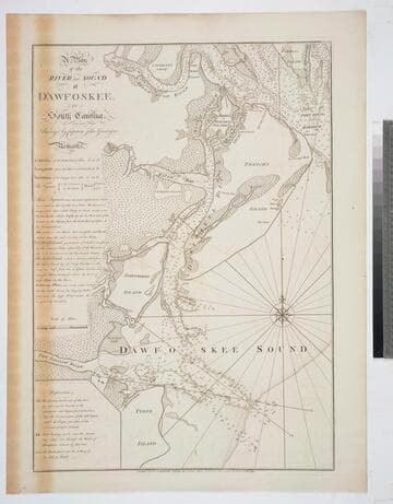
A Plan of the River and Sound of D'Awfoskee, in South Carolina. Survey'd by Captain John Gascoigne
Visual Materials
MS note: c 36. Prime meridian: London. Relief: no. Graphic Scale: Miles. Projection: Plane. Watermark: Crowned fleur-di-lis VI. Printing Process: Copper engraving. Verso Text: MS note: 349 10.
105:349 M
Image not available
Bay of Honduras, By Thos. Jefferys Geographer to His Majesty
Visual Materials
"BF 10. (upper right)" Prime meridian: London. Relief: pictorial. Projection: Cylindrical. Watermark: Crowned fleur-di-lis WF. Printing Process: Copper engraving. Verso Text: MS notes: 892 27.
105:892 M

Plan of Bahia Honda. ; Plan of Puerto de Cavañas
Visual Materials
Two maps on one sheet. Kashnor dates as ca. 1760. MS notes: 68 69 (upper right). Relief: hachures. Graphic Scale: Miles. Projection: Plane. Watermark: Crowned fleur-di-lis. Printing Process: Copper engraving. Verso Text: MS note: 375.
105:375 M

The Coast of Yucatan from Campeche to Ascension Bay with the West End of Cuba, by Thos. Jefferys Geographer to His Majesty
Visual Materials
Two maps joined to make one sheet. Prime meridian: London. Relief: pictorial & hachures. Graphic Scale: Leagues. Projection: Cylindrical. Watermark: Crowned fleur-de-lis LA. Printing Process: Copper engraving. Verso Text: MS note: 905.
105:905 M