Visual Materials
Amerique Septentrionale divisée en ses principales parties, ou sont distinqués les uns des autres Les Estats suivant qúils appartiennent presentemet aux Francois, Castillans, Anglois, Suedois Danois, Holandois. Tirée des Relations de toutes ces Nations
You might also be interested in
Image not available
Amerique Septentrionale divisée en ses principales parties, ou sont distinqués les uns des autres Les Estats suivant qúils appartiennent presentemet aux Francois, Castillans, Anglois, Suedois Danois, Holandois. Tirée des Relations de toutes ces Nations
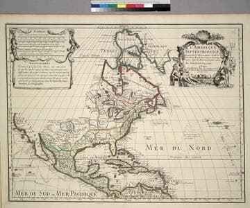
Visual Materials
Kashnor notes, "Shows California as an island, locating Pto. Francisco Draco, Santa Barbara and San Diego. The Terre de Jesso almost touches California, which shows the prevailing idea that Asia and America were only separated by a narrow strait." This is a reissue of the 1674 map, see McLaughlin 55. See also 093:162 for another copy. Title cartouche, scale decoration.. Prime meridian: Ferro. Relief: pictorial. Graphic Scale: Miles, leagues. Projection: Pseudocylindrical. Printing Process: Copper engraving. Other Features: Cartouche. References: McLaughlin 55; Wagner 409b; Wheat 58; Tooley 37 (Plate 44) and 38; Leighly 64; Jaillot I, Aa(5). Verso Text: MS notes: 5 161.
093:161 M
Image not available
Amerique Septentrionale divisée en ses principales parties, ou sont distinqués les uns des autres Les Estats suivant qúils appartiennent presentemet aux Francois, Castillans, Anglois, Suedois Danois, Holandois. Tirée des Relations de toutes ces Nations
Visual Materials
Kashnor notes, "Shows California as an island, locating Pto. Francisco Draco, Santa Barbara and San Diego. The Terre de Jesso almost touches California, which shows the prevailing idea that Asia and America were only separated by a narrow strait." This is a reissue of the 1674 map, see McLaughlin 55. Kashnor dates as [1696]. Date has been removed. This map duplicates 093:161. Title cartouche, scale decoration.. Prime meridian: Ferro. Relief: pictorial. Graphic Scale: Miles, leagues. Projection: Pseudocylindrical. Printing Process: Copper engraving. Other Features: Cartouche. References: McLaughlin 55; Wagner 409b; Wheat 58; Tooley 37 (Plate 44) and 38; Leighly 64; Jaillot I, Aa(5). Verso Text: MS note: 162.
093:162 M
Image not available
Nouveau (Le) Continent, ou l'Amerique divisée en Septentrionale ey Meridionale, ou l'on trouve, lers Climats, les Meridiens, les differentes Possessions, les Peuples Naturels Libres, les differentes Religions, et les differentes Langues
Visual Materials
Kashnor notes, "Shows the Californian coast to Cape Blanco, locating Pto. S. Francois Drack, Monterey, &c.; also Santa in New Mexico." Table of European possessions, divisions by language, religion, etc.. Prime meridian: Ferro. Relief: pictorial. Graphic Scale: Miles, leagues. Projection: Pseudocylindrical. Watermark: Chained Maltese cross lettering. Printing Process: Copper engraving. Verso Text: MS note: 283/105.
105:283 M
Image not available
Hemisphere Septentrional pour voir plus distinctement Les Terres Arctiques
Visual Materials
Kashnor notes, "Shows California as a peninsula, and locates Port St. Francois and the coast to Cape Blanco. Delisle appears to be the earliest map maker to show California with a definite coastline." See also 105:231M. Prime meridian: Ferro. Relief: pictorial. Projection: Conic. Watermark: Chained Maltese cross lettering. Printing Process: Copper engraving. Verso Text: MS notes: Delisle Hemisphere Septentrional.
105:230 M
L'Amerique Septentrionale, Dresée sur les Observations de. Mrs. de l'Academie Royale des Sciences. & quelques autres, & sur les Memoires les plus recens
Visual Materials
Kashnor notes, " Shows the Gulf of California reaching only as far north as the Bona Guia River, the north-west coast has its limit at Cap Mendocin. It locates the Sierra Nevada Mountains, Port de Drak and New Albion, and also the tracks of Cortez, Drake, Olivier, Mendana and Gaetana. One of the best maps to show the geographical knowledge of California at the beginning of the 18th century." George Carhart of Osher Map Library confirms this map to be state 2, published in [1701]. See 093:160M for a later version of this map. Cartouche and figured scale bar. Includes Avertissement.. Prime meridian: Ferro. Relief: pictorial. Graphic Scale: Leagues, various. Projection: Pseudocylindrical. Watermark: Chained Maltese cross. Printing Process: Copper engraving. Other Features: CartoucheFigures . Verso Text: MS notes: 72 (on folded left edge); 159 Mus. Bk St. 93/159 25.
093:159 M
Image not available
Mappe-Monde Dresée sur les Observations de Mrs. de l'Academie Royale des Sciences et quelques autres et sur les memoires les plus recens. A son Altesse Royale Monseigneur le Duc de Chartes
Visual Materials
Kashnor notes, "Shows the Gulf of California only reaching as high as the Bona Guia, but without the definite termination; also shows New Holland and part of New Zealand, with the tracks of Mendana, Dampier, Olivier, Tasman, Pelsart, Magellan and le Maire." This appears to be a later state of the 1700 map, see 093:180. The slant of South America has been corrected eastward, some new names appear on the west coast of Africa, and a new mountain range in Siberia. Image is lighter than 1700 original. See also 093:181, 105:244 and 105:245 for later editions. Cartouche - figures representing four continents. Prime meridian: Ferro. Relief: pictorial. Projection: Dual Hemisphere. Watermark: Chained Maltese cross. Printing Process: Copper engraving. Other Features: Cartouche. References: Shirley 603. Verso Text: MS notes: 245.
105:245 M