Visual Materials
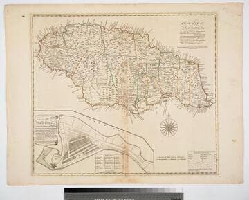
New and Exact Map of the Island of Antigua in America, according to an Actual and Accurate Survey, with the different Parishes, the Churches, Divisions, Boundaries; and a Plan of English Harbor

You might also be interested in

Martinico, Done from Actual Surveys and Observations, made by English Engineers whilst the Island was in their Possession, by Thomas Jefferys Geographer to the King
Visual Materials
Submap: Cul de Sac Royal. "VIII (upper right)" Prime meridian: Ferro. Relief: hachures. Graphic Scale: Leagues. Projection: Plane. Watermark: Crowned fleur-di-lis VI. Printing Process: Copper engraving. Other Features: Sub-maps. Verso Text: MS notes: 507 16.
105:507 M
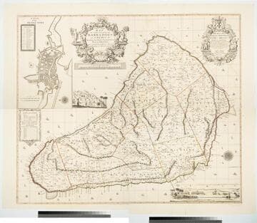
New and Exact Map of the Island of Barbadoes in America, According to an Actual and Accurate Survey made by William Mayo
Visual Materials
Kashnor notes, "Dedicated to James Bridges, Duke of Chandos. With inset plan of Bridgetown, prospect of Codrington College, and engraving representing the making of the survey; also statistics of population." See also 093:745M, another copy as engraved by John Senex 1722. Two elaborate cartouches. Submap - A Plan of Bridgetown. A view of Codrington College. View of surveyor with plane table, and native assistants with measuring wheel, surveying pole and chain. . Prime meridian: London. Relief: pictorial. Graphic Scale: Miles. Projection: Plane. Watermark: JW Whatman 1794. Printing Process: Copper engraving. Other Features: CartoucheSub-mapsVignettes. Verso Text: Ms notes: 174 4 sheets 23, 24, 25, 26..
105:174 M

Plan of the Island of St. John with the divisions of the Counties Parishes & the Lots as granted by Government likewise the Soundings round the Coast and Harbours
Visual Materials
Kashnor notes, "This is the first issue of Holand's map before it passed to Sayer and Bennett." Submap: Gulf of St. Laurence. Table: the Contents of the Respective Divisions of the Island of St. John. Cartouche: Fishing, farming view.. "Surveyed by Capt. Holland 1775." Prime meridian: London. Relief: no. Graphic Scale: Miles. Projection: Plane. Watermark: Crowned fleur-di-lis WF. Printing Process: Copper engraving. Other Features: Sub-mapsCartouche. Verso Text: MS notes: 754 4.
105:754 M

New and accurate Map of Connecticut and Rhode Island from the best Authorities
Visual Materials
Kashnor shows date as c.1775. [Longitude incorrectly shown.] MS note: 88 (on backing). Prime meridian: London. Relief: pictorial. Projection: Mercator. Watermark: Crowned seal of Britannia S&K. Printing Process: Copper engraving.
105:088

Accurate Map of North and South Carolina with their Indian Frontiers, showing in a distinct manner all the Mountains, Rivers, Swamps, Marshes, Bays, Creeks, Harbours, Sandbanks and Soundings on the Coast, with the Roads and Indian Paths as well as the Boundary or Provincial Lines, the Several Townships and other divisions of the Land in Both the Provinces; the whole from Actual Surveys by Henry Mouzon and others
Visual Materials
Noted as duplicate of 192531, 29-30 and 2813, #73-74. Submap: Harbour at Port Royal; Bar and Harbour of Charlestown.. Prime meridian: London. Relief: hachures. Projection: Cylindrical. Watermark: Crowned fluer-di-lis VI. Printing Process: Copper engraving. Other Features: Sub-maps. Verso Text: MS note: 73 H. E. H. Dupl. stamp..
105:073 M
New Map of Jamaica In which the Several Towns Forts & Settlements are Accurately laid down, as well as the situations & depths of the most noted Harbours and Anchoring Places, with the limits and boundaries of the different Parishes, as they have been regulated by Law, or settled by Custom, the greatest part Drawn or Corrected from actual Surveys Made by Mr. Sheffield and others
Visual Materials
Submap: General Plan of Port Royal in which Different States of the Town are Accurately laid Down. . Prime meridian: London. Relief: pictorial. Graphic Scale: Miles. Projection: Cylindrical. Watermark: Crowned fleur-di-lis IV. Printing Process: Copper engraving. Other Features: Sub-maps. Verso Text: MS notes: 801 J5..
093:801 M