Visual Materials
To His Royal Highness the Duke of York, This Map of the County of Middlesex, in the Island of Jamaica, Constructed from Actual Surveys, under the Authority of The. Hon. House of Assembly; by Whom it hath been Examined, and Unanimously Approved, Is, With Permission, Most Humbly Inscribed by His Royal Highness's Faithful & most Devoted Servant, James Robertson, A.M. 1804 London: Published November 1st, 1804 b y James Robertson, A.M., late of Jamaica. Engraved by S. I. Neele, No. 352 Strand, London
You might also be interested in

New and Exact Map of the Island of Barbadoes in America, According to an Actual and Accurate Survey made in the Years 1717 to 1721 Approved by the Royal Society & Authorized by His Majesty's Royal Licence by William Mayo
Visual Materials
Kashnor notes, "Dedicated to James Bridges, Duke of Chandos. With inset plan of Bridgetown, prospect of Codrington College, and engraving representing the making of the survey; also statistics of population." See also 105:174 for another copy. Two elaborate cartouches. Submap - A Plan of Bridgetown. A view of Codrington College. View of surveyor with plane table, and native assistants with measuring wheel, surveying pole and chain. . Prime meridian: London. Relief: pictorial. Graphic Scale: Miles. Projection: Plane. Watermark: IHS LV II --DARY. Printing Process: Copper engraving. Other Features: CartoucheSub-mapsVignettes. Verso Text: Ms notes: 745 47.
093:745 M
![Plan of Cumberland Harbr. on the So. Side of Cuba. Formerly call'd Walltenam Bay. Most humbly dedicated to his Royal Highness William Augustus Duke of Cumberland, &c:&c:&c. By Capt. Phi. Durell 1741 [Manuscript map]](/_next/image?url=https%3A%2F%2Frail.huntington.org%2FIIIF3%2FImage%2F22APN4KV8LBH%2Ffull%2F%5E360%2C%2F0%2Fdefault.jpg&w=750&q=75)
Plan of Cumberland Harbr. on the So. Side of Cuba. Formerly call'd Walltenam Bay. Most humbly dedicated to his Royal Highness William Augustus Duke of Cumberland, &c:&c:&c. By Capt. Phi. Durell 1741 [Manuscript map]
Visual Materials
Kashnor notes, "This is the original drawing by Durell, from which Fourdrinier engraved the chart published on the 3rd November, mounted on linen, with silk binding along the edge, with ties." [ties no longer attached] See 105:385M for the printed version by Fourdrinier. Cumberland Bay is now known as Guantanamo. Cartouche: garlands & leaves.. Relief: pictorial. Graphic Scale: Miles. Projection: Plane. Other Features: Cartouche. Verso Text: MS notes: 758 Cumberland Bay.
093:758 M

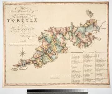
To Isaac Pickering Esqr of Fox Lease Hants this Plan of Tortola From actual Survey by George King is dedicated by His most obedient humble Servant Robt. Wilkinson
Visual Materials
Kashnor notes, "With a list of 104 plantations indicated on plan, with owners names." Pickering held the westernmost point of this island in the British Virgin Islands. Reference table listing owners and parcel numbers. MS note: 843 29. Prime meridian: GM. Relief: hachures. Graphic Scale: Miles, chains. Projection: Plane. Printing Process: Copper engraving. Verso Text: MS note: 843.
093:843 M

To the Right Honourable Robert Earl of Holdernesse, This Map of the County of Cornwall, in the Island of Jamaica laid down from the papers and under the Direction of Henry Moore Esqr, His Majesty's Lieutenant Governor and Commander in Chief of that Island in the years 1756..57..58..59..60 & 61 & from a great number of Actual Surveys performed by the Publishers is humbly inscribed by His Lordship's Most Obedient and Most Humble Servants, Thos. Craskell, Engineer, Jas. Simpson, Surveyor
Visual Materials
Cartouche: Elaborate farming scene; Stair steps around scale. . Relief: no. Graphic Scale: Miles. Projection: Plane. Printing Process: Copper engraving. Other Features: Cartouche. Verso Text: Label with MS note: Parishes of St. James Westmoreland Hanover St. Elizabeth .
093:810 M

To the Right Honourable George Grenville, Esqr., First Lord Commissioner of the Treasury, Chancellor and under Treasurer of the Exchequer, &c. &. This Map of the County of Surrey, in the Island of Jamaica laid down from the papers and under the Direction of Henry Moore Esqr, His Majesty's Lieutenant Governor and Commander in Chief of that Island in the years 1756..57..58..59..60 & 61 & from a great number of Actual Surveys performed by the Publishers is humbly inscribed by His Most Obedient and Most Humble Servants, Thos. Craskell, Engineer, Jas. Simpson, Surveyor
Visual Materials
Cartouche: Elaborate harbor scene; Stair steps around scale. . Relief: no. Graphic Scale: Miles. Projection: Plane. Printing Process: Copper engraving. Other Features: Cartouche. Verso Text: Red ribbon, Label with MS note: Parish of St. George the Blue Portland St. Thomas in the East St. Andrew Port Royal St. David..
093:809 M
Image not available
General Chart exhibiting the Discoveries made by Captain James Cook in this and his Two Preceeding Voyages, with the tracks of the Ships under his command, by Lieut't Hen'y Roberts of His Majesty's Royal Navy
Visual Materials
Kashnor notes, "Shows a fine coast of North-West America, this was the most exact map to date." Same as 105:025. Issued as separate map at same time as official report of Cook's voyages. See 093:013,015,016 related maps. Hearne's explorations located too far north. Shows tracks of Endeavor and Resolution on all three of Cook's voyages. Prime meridian: GM. Relief: no. Graphic Scale: No. Projection: Mercator. Printing Process: Copper engraving. Verso Text: MS. note: No 21.
093:021 M