Visual Materials
To the Right Honourable George Grenville, Esqr., First Lord Commissioner of the Treasury, Chancellor and under Treasurer of the Exchequer, &c. &. This Map of the County of Surrey, in the Island of Jamaica laid down from the papers and under the Direction of Henry Moore Esqr, His Majesty's Lieutenant Governor and Commander in Chief of that Island in the years 1756..57..58..59..60 & 61 & from a great number of Actual Surveys performed by the Publishers is humbly inscribed by His Most Obedient and Most Humble Servants, Thos. Craskell, Engineer, Jas. Simpson, Surveyor

You might also be interested in

To the Right Honourable Robert Earl of Holdernesse, This Map of the County of Cornwall, in the Island of Jamaica laid down from the papers and under the Direction of Henry Moore Esqr, His Majesty's Lieutenant Governor and Commander in Chief of that Island in the years 1756..57..58..59..60 & 61 & from a great number of Actual Surveys performed by the Publishers is humbly inscribed by His Lordship's Most Obedient and Most Humble Servants, Thos. Craskell, Engineer, Jas. Simpson, Surveyor
Visual Materials
Cartouche: Elaborate farming scene; Stair steps around scale. . Relief: no. Graphic Scale: Miles. Projection: Plane. Printing Process: Copper engraving. Other Features: Cartouche. Verso Text: Label with MS note: Parishes of St. James Westmoreland Hanover St. Elizabeth .
093:810 M

To the Right Honourable Wills, Earl of Hillsborough, First Commissioner of Trade and Plantations, this Map of the County of Middlesex in the Island of Jamaica, laid down from the Papers and under the direction of Henry Moore, Esqre., His Majesty's Lieutenant Governor and Commander in Chief of the Island in the years 1756-1761 (and from a great number of Actual Surveys performed by the Publishers) is humbly Inscribed by His Lordship's Most Obedient & Most Humble Servants Thos. Craskell, Engineer, Jas. Simpson, Surveyor
Visual Materials
Kashnor notes, " A very fine topographical map, indicating the different kinds of palntations, roads, boundaries, &c." Torn center seam, careful. Cartouche: Boar hunt with dogs. Elaborate scale artwork upper right.. Relief: no. Graphic Scale: Miles. Projection: Plane. Printing Process: Copper engraving. Other Features: CartoucheArt Work.
105:467 M

To the Right Honourable George, Earl of Halifax, One of His Majesty's Principal Secretary's pf State, &c. &c. This Map of the Island of Jamaica. laid down from the Papers, and under the direction of Henry Moore, Esqr. His Majesty's Lieutenant Giovernor, and Commander in Chief of that Island in the Years 1756, 57, 58, 59, 69 & 61; from a great Number of Actual Surveys performed by the Publishers is humbnly Inscribed by His Lordships Most Obedient & Most Humble Servants, Thos. Craskell, Engineer, Jas. Simpson, Surveyor
Visual Materials
Kashnor notes, "The map locates all the existing sugar plasntations with mills." Cartouches: Dramatic memorial to George III; Scale mounted on monumental stairs.. Relief: pictorial. Graphic Scale: Miles. Projection: Plane. Printing Process: Copper engraving. Other Features: Cartouche. Verso Text: MS note: 808.
093:808 M
Image not available
Plan of the Harbour Town and Castles of Carthagena most humbly Presented to Edw. Vernon Esqr. Vice Admiral of the Blue and Commander in Chief of His Majesties Ships & Vessels in the West Indies by Capt. Phil: Durell Anno 1741
Visual Materials
This copy one Shilling. See 105:885 for two Shilling copy. Vignettes: NW by W Prospect of Carthagena Town; Castle Grande NNW; West Prospect of Bocca Chieca or St. Louis Castle, P. Fourdrinier sculp.; St Philipo; St. Jago; St. Josepho.. Relief: hachures. Graphic Scale: Miles. Projection: Plane. Printing Process: Copper engraving. Other Features: Vignettes. Verso Text: MS note: 655.
093:655 M
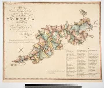
To Isaac Pickering Esqr of Fox Lease Hants this Plan of Tortola From actual Survey by George King is dedicated by His most obedient humble Servant Robt. Wilkinson
Visual Materials
Kashnor notes, "With a list of 104 plantations indicated on plan, with owners names." Pickering held the westernmost point of this island in the British Virgin Islands. Reference table listing owners and parcel numbers. MS note: 843 29. Prime meridian: GM. Relief: hachures. Graphic Scale: Miles, chains. Projection: Plane. Printing Process: Copper engraving. Verso Text: MS note: 843.
093:843 M
![Plan of Cumberland Harbr. on the So. Side of Cuba. Formerly call'd Walltenam Bay. Most humbly dedicated to his Royal Highness William Augustus Duke of Cumberland, &c:&c:&c. By Capt. Phi. Durell 1741 [Manuscript map]](/_next/image?url=https%3A%2F%2Frail.huntington.org%2FIIIF3%2FImage%2F22APN4KV8LBH%2Ffull%2F%5E360%2C%2F0%2Fdefault.jpg&w=750&q=75)
Plan of Cumberland Harbr. on the So. Side of Cuba. Formerly call'd Walltenam Bay. Most humbly dedicated to his Royal Highness William Augustus Duke of Cumberland, &c:&c:&c. By Capt. Phi. Durell 1741 [Manuscript map]
Visual Materials
Kashnor notes, "This is the original drawing by Durell, from which Fourdrinier engraved the chart published on the 3rd November, mounted on linen, with silk binding along the edge, with ties." [ties no longer attached] See 105:385M for the printed version by Fourdrinier. Cumberland Bay is now known as Guantanamo. Cartouche: garlands & leaves.. Relief: pictorial. Graphic Scale: Miles. Projection: Plane. Other Features: Cartouche. Verso Text: MS notes: 758 Cumberland Bay.
093:758 M