Visual Materials
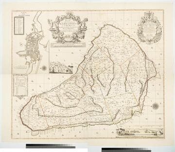
New and Exact Map of the Island of Barbadoes in America, According to an Actual and Accurate Survey made in the Years 1717 to 1721 Approved by the Royal Society & Authorized by His Majesty's Royal Licence by William Mayo

You might also be interested in
New and Exact Map of the Island of Barbadoes in America, According to an Actual and Accurate Survey made by William Mayo
Visual Materials
Kashnor notes, "Dedicated to James Bridges, Duke of Chandos. With inset plan of Bridgetown, prospect of Codrington College, and engraving representing the making of the survey; also statistics of population." See also 093:745M, another copy as engraved by John Senex 1722. Two elaborate cartouches. Submap - A Plan of Bridgetown. A view of Codrington College. View of surveyor with plane table, and native assistants with measuring wheel, surveying pole and chain. . Prime meridian: London. Relief: pictorial. Graphic Scale: Miles. Projection: Plane. Watermark: JW Whatman 1794. Printing Process: Copper engraving. Other Features: CartoucheSub-mapsVignettes. Verso Text: Ms notes: 174 4 sheets 23, 24, 25, 26..
105:174 M

Barbadoes, Surveyed by William Mayo, Engraved and Improved by Thomas Jefferys, Geographer to the King
Visual Materials
Vignettes: Two views of island from shipboard.. Prime meridian: London. Relief: hachures. Graphic Scale: Miles, leagues. Projection: Plane. Printing Process: Copper engraving. Other Features: Vignettes. Verso Text: MS note: 747.
093:747 M

Island of Barbadoes. Divided into its Parishes, with the roads, paths. &c. According to an Actual and Accurate Survey. By H. Moll Geographer 1728
Visual Materials
Kashnor notes, " A scarce map, showing the plantations and the names of the owners." MS note: 743 (on backing). Relief: pictorial. Graphic Scale: Miles. Projection: Plane. Printing Process: Copper engraving. Verso Text: MS note: 743 (on backing).
093:743 S

Curacao, from the Dutch Originals. of Gerald Van Keulen, Regulated by Astronomical Observations
Visual Materials
See also 093:761M for French version of this map with earlier date. Submap: Plan of Fort Amsterdam. Vignettes: Four island views from sea.. Prime meridian: London, Ferro. Relief: hachures. Graphic Scale: Leagues. Projection: Plane. Printing Process: Copper engraving. Other Features: Sub-mapsVignettes. Verso Text: MS note: 762.
093:762 M

New and Exact Map of the Island of Antigua in America, according to an Actual and Accurate Survey, with the different Parishes, the Churches, Divisions, Boundaries; and a Plan of English Harbor
Visual Materials
Submap of English Harbor. Submap of English Harbor. MS note: 157 (on backing). Relief: pictorial. Graphic Scale: Miles. Projection: Plane. Watermark: Crowned seal. Printing Process: Copper engraving. Other Features: Sub-maps.
105:157 M
Image not available
Blachford's New Chart of the River St. Laurence, from Cape Roziers to Quebec taken from an Original French Survey, accompanied with many remarks & Observations of Captn. John Kirby, late of the Ship Albion
Visual Materials
Kashnor notes, " with inset plan of the River St. Lawrence from Green Island to Quebec on a large scale, by Rt. Blachford, charts of Gaspee Bay, Quebec Basin, Seven Sisters Bay &c. and views of land falls." Contains detailed sailing directions suggested by Capt. Kirby. Cartouche with hunter, birds, ship. Submaps: Continuation of the River from Quebec to Montreal; Quebec Bason; A Particular Plan of the River St. Laurence, From Green Island to Quebec, on a large Scale, by Rt. Blachford. 1811; Gaspee Bay; Havre St. Nicholas; Bay of Seven Islands; Parokeet Islands and Mingan Island; Mingan Town. Vignettes: View of Belle Chase Windmill; Cape Goose; Three Mountains; Cape l'Original; Cape Gaspee; view of land between Island Bonaventura and Cape Roziers; view of the land between Cape de Monts Pelles and Point de Manicouagan; Egg Island.. Relief: hachures. Graphic Scale: Leagues. Projection: Plane. Printing Process: Copper engraving. Other Features: CartoucheSub-mapsVignettes. Verso Text: MS note: 353.
093:353 M