Visual Materials
Curacao, from the Dutch Originals. of Gerald Van Keulen, Regulated by Astronomical Observations

You might also be interested in

Curacao Tiré des Originaux Hollandois de Van Keulen Dressé sur les dernieres Observations
Visual Materials
See also 093:762M for English version of this map with later date. Submap: Fort Amsterdam. Vignettes: Four island views from sea.. Prime meridian: London, Ferro. Relief: hachures. Graphic Scale: Leagues. Projection: Plane. Watermark: Chained maltese cross lettering. Printing Process: Copper engraving. Other Features: Sub-mapsVignettes. Verso Text: MS note: 761.
093:761 M
Image not available
Landkaart van de Volkplantingen Suriname en Berbice
Visual Materials
Kashnor dates as [Amsterdam, ca. 1750.] [Cartographer may be Tirion, see 093:664s for similar techniques] Submap; Plan van de Stad Paramaribo. Prime meridian: Ferro. Relief: no. Graphic Scale: Leagues. Projection: Cylindrical. Watermark: Crowned device IH & ZONCN. Printing Process: Copper engraving. Other Features: Sub-maps. Verso Text: MS note: 665/#93.
093:665 S
Image not available
Land-Kaart van het Eiland en de Volksplanting van Cayenne aan de Kust van Zuid-Amerika
Visual Materials
Kashnor dates as [Amsterdam ca. 1750]. This map may derive from Jeffery's 1760 maps, see 093:659 and 660. This map is made to the same scale as the Jeffery's map. Submap: Platte Grond van de Stad en 't Kasteel van Cayenne.. Prime meridian: Ferro. Relief: hachures. Graphic Scale: Leagues. Projection: Cylindrical. Watermark: Crowned fleur-di-lis VI. Printing Process: Copper engraving. Other Features: Sub-maps. Verso Text: MS note: 661.
093:661 S

Plan of the Attack against Basseterre on the Island of Guadaloupe By a Squadron of his Majesty's Ships of War Commanded by Commodore Moore on the 22d. Jany. 1759. also the Incampments of the British Army Commanded by Genl. Hopson, and the French Intrenchments after they Abandoned the Town and Citadel: Drawn on the Spot by Lieut. Col. Rycaut of the Marines
Visual Materials
Submap: Plan of Fort Royal. Vignette: Section of fort walls. MS note: 776. Relief: hachures. Graphic Scale: Yards. Projection: Plane. Watermark: Device VI. Printing Process: Copper engraving. Other Features: Sub-mapsVignettes. Verso Text: MS note: 776.
093:776 M
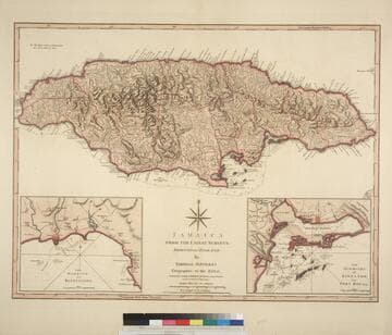
Jamaica from the latest surveys; Improved and Engraved by Thomas Jefferys Geographer to the King
Visual Materials
Two insert maps.See also 093:796M for a later version. Submap: Harbour of Bluefields; Harbour of Kingston aand Port Royal.. Prime meridian: London, Ferro. Relief: hachures. Graphic Scale: Miles, leagues. Projection: Cylindrical. Printing Process: Copper engraving. Other Features: Sub-maps. Verso Text: MS note: 795.
093:795 M

St. Christophers, or St. Kitts, surveyed By Anthony Ravell Esqr. Surveyor General of the Islands of St. Christophers, Nevis, & Montserrat. Engraved by Thomas Jefferys Geographer to the King
Visual Materials
See 093:827M for an earlier copy. Vignette: Nevis from shipboard Submap: Nevis, by Thomas Jefferys.. Prime meridian: London, Ferro. Relief: hachures. Graphic Scale: Miles, leagues. Projection: Cylindrical. Printing Process: Copper engraving. Other Features: VignettesSub-maps. Verso Text: MS notes: 828.
093:828 M