Visual Materials
Compleat Map of the West Indies, Containing the Coasts of Florida, Louisiana, New Spain, and Terra Firma: with all the Islands. By Samuel Dunn, Mathematician

You might also be interested in

Map of the Isle of Cuba, with the Bahama Islands, Gulf of Florida, and Windward Passage: Drawn from English and Spanish Surveys. Engraved by Thomas Jefferys, Geographer to His Majesty
Visual Materials
Prime meridian: London, Ferro. Relief: pictorial. Graphic Scale: Miles, leagues. Projection: Cylindrical. Watermark: Fleur-di-lis on coat of arms. Printing Process: Copper engraving.
093:754 S
Image not available
Western Coast of Louisiana and The Coast of New Leon
Visual Materials
Kashnor notes, "An early map to give the correct outlines of present-day Texas." Across the interior is the note, "Vast Plains which are continual Savanna intermix'd with Woods and full of Wild Beeves, They are inhabited by the Canokosses the Ebahamas, Caouches, Quelamelouches, Teaos and Several other Tribes of Wandering Indians." Prime meridian: London, Ferro. Relief: pictorial. Graphic Scale: Leagues. Projection: Cylindrical. Watermark: Crowned fleur-di-lis VI. Printing Process: Copper engraving. Verso Text: MS note: 585.
093:585 M
Image not available
New Map of Nova Scotia, and Cape Breton Island with the adjacent parts of New England and Canada, Composed from a great number of actual Surveys; and other material Regulated by many new Astronomical Observations of the Longitude as well as Latitude; by Thomas Jefferys, Geographer to the King
Visual Materials
See map 093:269M for earlier edition. Note border change. Prime meridian: Ferro. Relief: pictorial. Projection: Conic. Watermark: Crowned fleur-di-lis VI. Printing Process: Copper engraving. Other Features: Cartouche. Verso Text: MS note: 270 34.
093:270 M
Image not available
Map of North America and The West Indies by L. S. de la Rochette
Visual Materials
Kashnor notes, "One of the last maps issued showing the Illinois, Ohio, Michigan and Wisconsin country as part of Canada and the old colonies." Submap: Supplement for Hudsons and Baffins Bays.. Prime meridian: London, Ferro. Relief: pictorial & hachures. Graphic Scale: Miles, leagues. Projection: Pseudocylindrical. Watermark: Crowned fleur-di-lis over LVC. Printing Process: Copper engraving. Other Features: Sub-maps. Verso Text: MS notes: West Indies 14 13 12 North America 10 11 520.
093:520 M

Algemeene Kaart van de Westindische Eilanden. te Amsterdam by Isaak Tirion
Visual Materials
Kashnor dates as ca. 1750. MS notes: No. 108 174. Prime meridian: Ferro. Relief: pictorial. Projection: Conic. Watermark: Crowned fleur-de-lis Van der Ley. Printing Process: Copper engraving. Verso Text: MS note: 705.
093:705 M
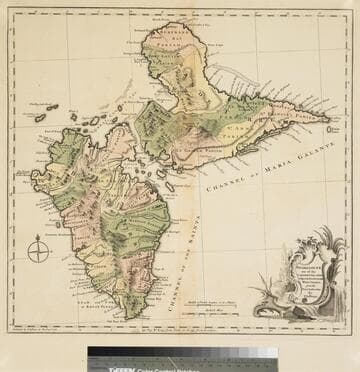
Guadaloupe one of the Caribbee Islands Subject to France in the West Indies, from the Best Authorities By T. Jefferys
Visual Materials
Kashnor dates as [1760]. RLIN record suggests 1768 and provides appeared in information. Cartouche: water falls & plants. Oversize binding spine still attached. Note: mile and league scales do not match.. Prime meridian: Ferro, London. Relief: pictorial & hachures. Graphic Scale: Miles, leagues. Projection: Cylindrical. Watermark: Crowned fleur-de-lis VI. Printing Process: Copper engraving. Other Features: Cartouche. Verso Text: MS notes: 93/775 148 La Guadaloupe La Guadalupe .
093:775 M