Opening Hours
Daily: 10 A.M.–5 P.M.
Closed on Tuesdays
1151 Oxford Road
San Marino, CA 91108
Visual Materials
Daily: 10 A.M.–5 P.M.
Closed on Tuesdays
1151 Oxford Road
San Marino, CA 91108

Visual Materials
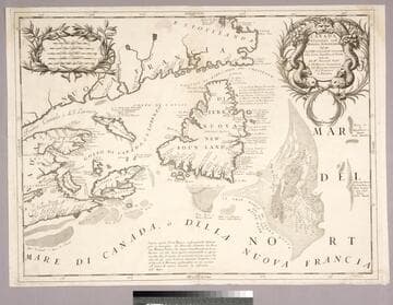
Kashnor notes, "Showing the mouth of the St. Laurence, with Newfoundland, Cape Breton Island, and parts of Nova Scotia and the Coast of Canada." Kashnor dates ca. 1690. Coronelli was active in Venice. Fish entwined cartouche.. Relief: no. Graphic Scale: Miles, leagues. Projection: Cylindrical. Watermark: Small circled fleur-di-lis.. Printing Process: Copper engraving. Other Features: Cartouche. References: Kershaw (Canada) 162. Verso Text: MS note: 251.
093:251 M
Image not available
Visual Materials
Kashnor notes, " Shows the Illinois Country and the Western Territory, locating Chicago and the River Cuyahoga in Ohio Country." MS note: 522 (on backing). Prime meridian: London. Relief: pictorial. Graphic Scale: Miles. Projection: Pseudocylindrical. Printing Process: Copper engraving. Verso Text: MS note: 522 (on backing).
093:522 S
Image not available
Visual Materials
Kashnor notes, "Showing parts of Brazil and Guiana." Map appeared in Coronelli's Atlante Veneto (RB 283753, vol. 1). Location and date taken from Atlante Veneto. Prime meridian: Ferro. Relief: pictorial. Projection: Pseudocylindrical. Printing Process: Copper engraving. Verso Text: MS note: 642.
093:642 M
Image not available
Visual Materials
Kashnor notes, "An interesting map, locating the countries of the Choctaw, Chicasaw, Cherokee and Creek Indians." Kashnor dates as [1790]. Georgia extends to the Mississippi River. RLIN record gives [Philadelphia] as publication site, ca. 1795 as pub. date. MS note: 395 (on backing). Prime meridian: London, Philadelphia. Relief: no. Graphic Scale: Miles. Projection: Pseudocylindrical. Printing Process: Copper engraving. Verso Text: MS note: 395 (on backing).
093:395 S
Image not available
Visual Materials
Kashnor dates as ca. 1690. This is a Nolin copy of Coronelli's map, published in Paris for the Italian market, so is probably from the mid 1700's. RLIN record suggests 1680 for publication date. Cartouche: crudely copied figures.. Prime meridian: Ferro. Relief: pictorial. Graphic Scale: Leagues. Projection: Cylindrical. Watermark: Circular device wit fleur-di-lis. Printing Process: Copper engraving. Other Features: Cartouche. Verso Text: MS note: 680.
093:680 M
Visual Materials
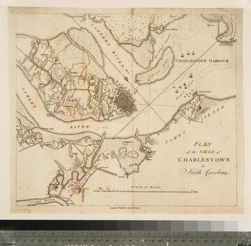
Kashnor notes, "This shows Charlestown Harbour from Fort Sullivan to Charlestown Neck, and locating the positions of the British Fleet with the boom across Cooper's River. On the neck is shown the encampment of the British Forces, and the three parallels which eventually led to the fall of the town." The siege of Charleston ended May 12, 1779 with surrender to British forces. MS note: 72 (on backing). Relief: pictorial & hachures. Graphic Scale: Miles, furlongs. Projection: Plane. Printing Process: Copper engraving. Verso Text: MS note: 72 (on backing).
093:072 S