Visual Materials
Georgia, from the latest Authorities
You might also be interested in

Map of Martinico, from the latest and best Authorities
Visual Materials
Kashnor dates as ca. 1759. Submap: Map of that part of Guadaloupe, where the English made their Descent, Jany. 23 1759. MS note: 818 (on backing). Prime meridian: London. Relief: hachures. Graphic Scale: Miles. Projection: Cylindrical. Printing Process: Copper engraving. Other Features: Sub-maps. Verso Text: MS note: 818 (on backing).
093:818 S

A new and accurate map of the province of Georgia in North America
Visual Materials
Kashnor notes, "Shows the old trading paths and the Hunting Grounds of the Cherokees." Kashnor dates c.1776. RLIN record notes date as [1779?] and place of publication as [London?] and as appearing in The Universal Magazine of 1779. See 093:391 and 105:103 for additional copies. MS note: 94 (on backing). Prime meridian: [Ferro]. Relief: pictorial. Projection: Cylindrical. Watermark: Crowned circular seal. Printing Process: Copper engraving. Other Features: Cartouche. Verso Text: MS note: 32 94(on backing).
093:094 S
Image not available
Louisiana : as formerly claimed by France ; now containing part of British America to the east & Spanish America to the west of the Mississipi ; from the best authorities / by T. Kitchin Geogr
Visual Materials
Kashnor dates as ca. 1759. RLIN record gives appeared in information, date. MS note: 295 (on backing). Prime meridian: London, Ferro. Relief: pictorial. Graphic Scale: Miles. Projection: Pseudocylindrical. Printing Process: Copper engraving. Verso Text: MS note: 295 (on backing).
093:295 S
Image not available
Map of the United States of America, with part of the adjoining provinces from the latest Authorities
Visual Materials
Kashnor notes, " Shows the Illinois Country and the Western Territory, locating Chicago and the River Cuyahoga in Ohio Country." MS note: 522 (on backing). Prime meridian: London. Relief: pictorial. Graphic Scale: Miles. Projection: Pseudocylindrical. Printing Process: Copper engraving. Verso Text: MS note: 522 (on backing).
093:522 S
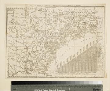
General Map of North America from the Latest Observations
Visual Materials
Kashnor gives date as [1776] RLIN record suggests 1778. Map includes distance chart between 29 American and Canadian cities. Bounds of Hudsons Bay [Co.] shown by Treaty of Utrecht. MS note: 102 (on backing). Prime meridian: London. Relief: pictorial. Projection: Mercator. Printing Process: Copper engraving. Verso Text: MS note: 1776.
105:102 S
Image not available
Accurate Map of Louisiana, and the Territory in Dispute between the English & French
Visual Materials
Kashnor notes, "Includes parts of Virginia, North and South Carolina, Georgia and Florida." Kashnor dates as ca. 1755. RLIN record suggests 1761. RLIN record covers a photocopy but is included to add data of appeared in information. MS note: 421 (on backing). Prime meridian: London. Relief: pictorial. Graphic Scale: Miles. Projection: Pseudocylindrical. Printing Process: Copper engraving. Verso Text: MS note: 421 (on backing).
093:421 S