Opening Hours
Daily: 10 A.M.–5 P.M.
Closed on Tuesdays
1151 Oxford Road
San Marino, CA 91108
Visual Materials
Daily: 10 A.M.–5 P.M.
Closed on Tuesdays
1151 Oxford Road
San Marino, CA 91108

Visual Materials
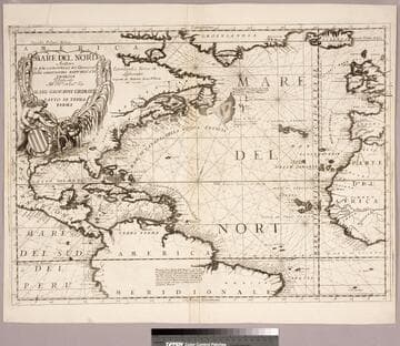
Kashnor notes, "A very fine Venetian map, showing the American coast from Greenland to Brazil,with the West Indies; also Great Britain, the Peninsula, and part of the west coast of Africa. It indicates New France, Acadia, N. Inghilt, Nouvo York, N. Svecia, Virginia, and Carolina." Kashnor dates as ca. 1680. Cartouche: Mermen with shield & seaweed.. Prime meridian: Ferro. Relief: no. Projection: Cylindrical. Watermark: Two crescents. Printing Process: Copper engraving. Other Features: Cartouche. Verso Text: Ms note: Vi 39 330.
105:330 M
Image not available
Visual Materials
This is Sanson's version of famous de l'Isle map with South America curving west. See 093:610 or RB 295821. Kashnor dates as ca. 1680, but de l'Isle's map preceded this one. Kashnor notes, "Shows the Argentine provinces as "Provinces de Rio de la Plata." Cartouche: Figures & scrolling. MS note: No. 1 (upper left). Prime meridian: Ferro. Relief: pictorial. Graphic Scale: Leagues. Projection: Pseudocylindrical. Printing Process: Copper engraving. Verso Text: MS notes: 631.
093:631 M
Image not available
Visual Materials
Kashnor dates as ca. 1690. This is a Nolin copy of Coronelli's map, published in Paris for the Italian market, so is probably from the mid 1700's. RLIN record suggests 1680 for publication date. Cartouche: crudely copied figures.. Prime meridian: Ferro. Relief: pictorial. Graphic Scale: Leagues. Projection: Cylindrical. Watermark: Circular device wit fleur-di-lis. Printing Process: Copper engraving. Other Features: Cartouche. Verso Text: MS note: 680.
093:680 M
Image not available
Visual Materials
Kashnor notes, "Includes the southern parts of Brazil and Peru, with Paraguay and the whole continent to Cape Horn." For another copy see RB 105:870. Cartouche: Pictorial with figures. Submap: Plan de la Ville de Santiago. Prime meridian: Ferro. Relief: pictorial. Graphic Scale: Leagues. Projection: Pseudocylindrical. Watermark: Fleur-de-lis. Printing Process: Copper engraving. Verso Text: MS note: 910.
105:910 M
Image not available
Visual Materials
Kashnor notes, " A curious map of the Illinois country, locating Chicago River, and having observations relating to Fathers Marquette and Joliet's journey down the Wisconsin River." Kashnor dates ca. 1690. Scenes of Indians, one being devowered by an alligator. MS note 597 (on backing).. Prime meridian: Ferro. Relief: no. Graphic Scale: Leagues. Projection: Pseudocylindrical. Watermark: Circled fleur-di-lis. Printing Process: Copper engraving. Verso Text: MS note 597 (on backing)..
093:597 S
Image not available
Visual Materials
Kashnor notes, "Shows the Californian coast to Cape Blanco, locating Pte. S. Francois Drak, Monterey, etc.; also Santa Fe in New Mexico." Kashnor dates as ca. 1760. MS note: CA. Prime meridian: Ferro. Relief: pictorial. Graphic Scale: Miles, leagues. Projection: Pseudocylindrical. Printing Process: Copper engraving. Verso Text: MS note: 205.
093:205 M