Visual Materials
Aerial view of Santa Monica beach

You might also be interested in

Aerial view of beach and Palisades, Santa Monica, California
Visual Materials
Aerial view facing north showing the coastline, beach houses, North Beach Bath House, and Palisades Park in Santa Monica, California, with Pacific Coast Highway and Ocean Avenue paralleling either side of Palisades Park.
photCL_555_05_17

Aerial view of Santa Monica beach
Visual Materials
Detailed aerial view looking east showing the beach and Casino Cafeteria below Palisades Park in Santa Monica, California, with the Hippodrome on Looff's Pleasure Pier partially visible towards bottom right.
photCL_555_05_33
Aerial view of Santa Monica beach at north end of Palisades
Visual Materials
Detailed aerial view looking east towards the coastline just below the north end of Palisades Park in Santa Monica, California, with beach house, dock, bluffs, and staircase visible.
photCL_555_05_35

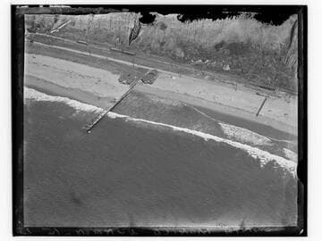
Aerial view of Santa Monica beach at north end of Palisades
Visual Materials
Detailed aerial view looking south showing the beach, dock and beach houses at the north end of Palisades Park in Santa Monica, California. Ocean Avenue and Adelaide Drive can both be seen heading eastward with Inspiration Point at their junction. The mouth of Santa Monica Canyon is seen in left edge of image.
photCL_555_05_34

Aerial view of Santa Monica beach and bluff, Santa Monica, California
Visual Materials
Aerial view of the beach and the Palisade Bluffs in Santa Monica, California, showing Palisades Park above and the Pacific Coast Highway with automobiles below.
photCL_555_05_43

Aerial detail of Santa Monica Pier
Visual Materials
Detailed aerial view looking northeast showing the Municipal Pier and Santa Monica Amusement Pier, including the Whirlwind Dipper roller coaster, Looff Hippodrome, and La Monica Ballroom, in Santa Monica, California. The beach north of the pier with the Santa Monica Bath House, and the south end of Palisades Park are visible.
photCL_555_05_24