Visual Materials
Aerial view of Santa Monica beach at north end of Palisades

You might also be interested in
Aerial view of Santa Monica beach at north end of Palisades
Visual Materials
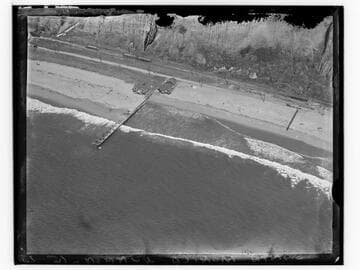
Detailed aerial view looking east towards the coastline just below the north end of Palisades Park in Santa Monica, California, with beach house, dock, bluffs, and staircase visible.
photCL_555_05_35

Beach Road north of Santa Monica, Cal
Visual Materials
Image of the Beach Road north of Santa Monica, California (in present-day Pacific Palisades), with the Japanese fishing village next to the Long Wharf at upper right. The Santa Monica Canyon Beach House can be seen at the mouth of the canyon beyond the wharf, with the beaches of Santa Monica and the bluffs farther south.
photCL_555_09_91

Aerial view of beach and Palisades, Santa Monica, California
Visual Materials
Aerial view facing north showing the coastline, beach houses, North Beach Bath House, and Palisades Park in Santa Monica, California, with Pacific Coast Highway and Ocean Avenue paralleling either side of Palisades Park.
photCL_555_05_17

Group on the beach at Santa Monica Girl Scout camp
Visual Materials
Image of a group of Girl Scouts walking onto the beach for a prayer meeting at Santa Monica Girl Scouts camp in Pacific Palisades, California. The Lighthouse Bathhouse can be seen in the distance at right at the mouth of Santa Monica Canyon.
photCL_555_06_995
Palisades at Santa Monica
Visual Materials
View of the Palisades bluff above the beach, with palm trees and fence, in Santa Monica, California. Railroad tracks and a dirt coast road are seen at left, along the beach.
photCL_555_01_1309

Palisades Park, Santa Monica
Visual Materials
Image of alluvial formation at Palisades Park with rustic fences in the background in Santa Monica, California. A portion of the Santa Monica Pier and La Monica Ballroom is seen at right as well as a boardwalk along the beach.
photCL_555_01_1304