Visual Materials
Aerial view of Santa Monica beach and bluff, Santa Monica, California

You might also be interested in

Aerial view of the California Incline, Santa Monica, California
Visual Materials
Aerial view of the coastline in Santa Monica, California, showing the California Incline road running through the bluffs, with beach houses along the coast and Palisades Park and buildings above.
photCL_555_05_16

Aerial view of streets above bluff, California Incline, Santa Monica, California
Visual Materials
Aerial view of the Palisade Bluffs in Santa Monica, California, showing homes along Ocean Avenue and Palisades Park above, with the California Incline road running through the cliffs at right.
photCL_555_05_42

Aerial view of beach and Palisades, Santa Monica, California
Visual Materials
Aerial view facing north showing the coastline, beach houses, North Beach Bath House, and Palisades Park in Santa Monica, California, with Pacific Coast Highway and Ocean Avenue paralleling either side of Palisades Park.
photCL_555_05_17

View from the bluff looking down on the beach, Santa Monica
Visual Materials
Image from the bluff looking down on the beach and automobiles on Pacific Coast Highway in Santa Monica, California, with the bluffs and Palisades Park visible at left.
photCL_555_06_2599

Aerial view of Santa Monica Canyon
Visual Materials
Aerial view of Santa Monica Canyon and Pacific Palisades, just north of the city of Santa Monica, California, with the beach and Pacific Coast Highway in the foreground and the bluffs at right.
photCL_555_09_110
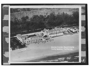
Marion Davies Beach Home, Santa Monica, California
Visual Materials
Aerial view of Ocean House (or the Oceanhouse Hotel) and the Sand and Sea Beach Club on the property that was formerly the mansion of actress Marion Davies on the beach in Santa Monica, California, with Palisades Beach Road (part of Pacific Coast Highway) and the bluffs below Palisades Park in the background.
photCL_555_06_2158