Visual Materials
View from the bluff looking down on the beach, Santa Monica

You might also be interested in

View from the bluff looking north toward the canyon, Santa Monica
Visual Materials
Image from the bluff looking north toward the intersections of Pacific Coast Highway with Entrada Drive and, a block north, with Channel Road and Chautauqua Boulevard in Santa Monica, California. With houses visible at right, automobiles on the Pacific Coast Highway and the beach at left. A Chevron Standard gasoline station can be seen near the intersection of Entrada Drive and a sign for "Gladstones 4 Fish" a block beyond.
photCL_555_06_2600
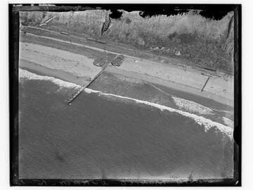
Bird's-eye view of Santa Monica beach, coast road and pier
Visual Materials
View looking south along the beach at Santa Monica, California, with the Palisades bluff on the left, and the coast road below. Other piers can be seen in the distance, along with beach clubs and other buildings on the beach. The "99 steps" are leading down from the bluff in middle distance.
photCL_555_01_1401

Aerial view of Santa Monica beach and bluff, Santa Monica, California
Visual Materials
Aerial view of the beach and the Palisade Bluffs in Santa Monica, California, showing Palisades Park above and the Pacific Coast Highway with automobiles below.
photCL_555_05_43

View from Palisades above beach, looking down to beach at Santa Monica
Visual Materials
View from Palisades Park above the beach in Santa Monica, California, looking down at the California Incline road, the beach, and Santa Monica Pier in the foreground and Ocean Park amusement piers in the background.
photCL_555_01_1319

Palisades Beach Road, Santa Monica
Visual Materials
Elevated view of houses along the beach in Santa Monica, California, looking south from the bluffs of Palisades Park, with railroad tracks and the Palisades Beach Road (part of the Roosevelt Highway, later Pacific Coast Highway), below, and the Santa Monica Pier and Ocean Park Pier visible in the distance. The mansion beach house of actress Marion Davies (which later became the Ocean House, or Oceanhouse hotel, and Sand and Sea Beach Club) is visible with multiple fireplaces in the foreground.
photCL_555_06_2551
Aerial view of Santa Monica beach at north end of Palisades
Visual Materials
Detailed aerial view looking east towards the coastline just below the north end of Palisades Park in Santa Monica, California, with beach house, dock, bluffs, and staircase visible.
photCL_555_05_35