Visual Materials
View of the steam dredge La Ballona

You might also be interested in
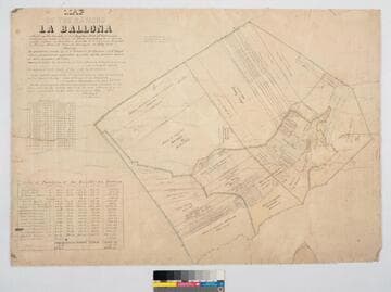
Map of the Rancho "La Ballona"
Manuscripts
Bordered by Pacific Ocean. Ballona Partition containing 13919.90 acres according to survey made by (L. Seebold for Hansen), under instructions from H. Hancock, July, 1858 showing partition made by J.J. Warner, H. Thomas & E. H. Boyd. Variation 14°15' E.. Inset with table listing partitions, names & land data. Inset with table listing boundary coordinates & distances. Machado (Young, Sanford, et al) family members are referenced on the partitions with acreage. "La Ballona Grant confirmee A. Machado, et al, patented December 8, 1873".
mssSolano SR_Map_0012.01
Image not available
William H. Fletcher photographs of La Fiesta de Los Angeles
Visual Materials
Card photographs by photographer W.H. Fletcher depicting various decorated horse-drawn floats and participants in the La Fiesta de Los Angeles parade in Los Angeles, California, circa 1895 and 1896. Includes images of floats for the cities of Pasadena and Fresno, the Board of Trade, the East Side Chemical Engine Company No. 3, the Mt. Lowe Railway (with the Anchor Laundry at 719 S. Los Angeles St. in the background), a view of a Chinese dragon, and other flower-bedecked carriages with participants, including groups of women with parasols and one with a banner labeled "Mexico 1800." There is also a picture of a woman standing on a horse.
photCL 434
Image not available
Photographs
Visual Materials
This collection of William H. Fletcher card photographs focus mainly on Los Angeles during a period of industrial expansion and population growth, with special attention on Los Angeles Street (which passes through Downtown Los Angeles) and what is now the Historic Core and Civic Center districts. There are also town and nature views of Pasadena, Santa Monica, Ventura, Redondo Beach, and Burbank. Images of Missions San Fernando Rey, San Luis Rey, and San Juan Capistrano are also included.
photCL 435

The Court at San Luis Rey Mission, June, 1894
Visual Materials
View of old courtyard of the San Luis Rey Mission.
photCL 435
Image not available
Photographs of Los Angeles and Vicinity by W.H. Fletcher
Visual Materials
This collection of William H. Fletcher commercial card photographs focus mainly on Los Angeles, California, during a period of industrial expansion and population growth in the late 1800s. The images depict various views around Los Angeles, which include Los Angeles Street and some of its intersections, the Main and Spring Streets junction, Old Chinatown, the College of Medicine at University of Southern California (in its second incarnation on Buena Vista Street, now North Broadway), Llewellyn Iron Works, Elysian Park, the Hollenbeck Home for retirees, and what may be William H. Fletcher's residence (see item 6). Also included are photographs of Colorado Boulevard, Fair Oaks Avenue, and Devil's Gate in Pasadena; the Los Angeles River; the Hotel Arcadia in Santa Monica; the Point Fermin Lighthouse in San Pedro; Ventura; Redondo Beach; and the California missions San Luis Rey, San Juan Capistrano, and San Fernando Rey.
photCL 435
