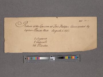
Manuscripts
Return of the Garrison at Fort Halifax
You might also be interested in
![Plan of the South Fort at Halifax and the Fort of St. George's Island with three elevations. [cartographic material]](/_next/image?url=https%3A%2F%2Frail.huntington.org%2FIIIF3%2FImage%2F22APN4MOI7DQ%2Ffull%2F%5E360%2C%2F0%2Fdefault.jpg&w=750&q=75)
Plan of the South Fort at Halifax and the Fort of St. George's Island with three elevations. [cartographic material]
Manuscripts
Manuscript map showing southern limits of Halifax, with the South Battery, the fort and number of mounted guns. Georges Island is depicted in detail with a proposed plan of fortifications. The island was named after King George II shortly after Halifax was settled by the British in 1749 and has been known as "George's Island" and more currently "Georges Island".
mssHM 15426
![A map of the harbour of Halifax [cartographic material]](/_next/image?url=https%3A%2F%2Frail.huntington.org%2FIIIF3%2FImage%2F22APN4MOG0IB%2Ffull%2F%5E360%2C%2F0%2Fdefault.jpg&w=750&q=75)
A map of the harbour of Halifax [cartographic material]
Manuscripts
Manuscript map showing the coastline and harbors from Jebucto (i.e. Chebucto) Head to Bedford Basin and Fort Sacville with bearing points, soundings and the channels. Halifax Harbour is depicted in great detail. Probably drawn by Charles Rivez from an original.
mssHM 15419
Image not available
Map of that part of Nova Scotia contained between Lunenburgh and the Bay Vert by Halifax and Pisiguit, including Cobiguit and Tatmagouch
Manuscripts
Manuscript map copy by Samuel Holland showing the coasts around Halifax, to Lunenburg Harbour, and from Minas Basin to Forts Cumberland and Lawrence on the Bay of Fundy. Also shows the road from Fort Sackvile to Pisiguit Fort and the old Acadian villages around Bedford Bay.
mssHM 15420
![Elevation of the store-house built at Fort-George: [cartographic material] which contains 2500 barrels of flower](/_next/image?url=https%3A%2F%2Frail.huntington.org%2FIIIF3%2FImage%2F22APN4MONA5I%2Ffull%2F%5E360%2C%2F0%2Fdefault.jpg&w=750&q=75)
Elevation of the store-house built at Fort-George: [cartographic material] which contains 2500 barrels of flower
Manuscripts
Manuscript plan showing outside, cross-section and top-view layout of the flour store house at Fort George. Located along the Hudson River at the junction with the Fish Creek River, the fort was later renamed Fort Hardy, which is located in modern day Schuylerville, Saratoga County, New York. Kashnor attributes the map to James Gabriel Montresor, the British engineer, who drew several maps of Fort George in late June 1759.
mssHM 15456

Jonathan Harrison map of the land between the Delaware and Susquehanna Rivers, with Indian towns and trails identified
Manuscripts
A manuscript map related to the boundary dispute between New York and New Jersey. Shows land between the upper Delaware River and the Upper Susquehanna River.
mssWalking