Manuscripts
Jonathan Harrison map of the land between the Delaware and Susquehanna Rivers, with Indian towns and trails identified

You might also be interested in
Image not available
Jonathan Harrison map of the land between the Delaware and Susquehanna Rivers, with Indian towns and trails identified
Manuscripts
A manuscript map related to the boundary dispute between New York and New Jersey.
mssWalking
Image not available
Excerpt from the minutes of the Indian council at Philadelphia…between Governor Patrick Gordon and the Chiefs of the Delaware and Shawnee, regarding Susquehannah River lands
Manuscripts
Excerpts from the minutes of the 1728 treaty council convened to deal with unauthorized settlements in the Delaware lands.
mssWalking
Image not available
New York and New Jersey boundary indenture
Manuscripts
Indenture between commissioners and surveyors representing New York and New Jersey relative to settling the north partition point between New York and New Jersey; includes affiavits and map of Delaware River.
mssHM 1260

Map of the portion of the Country in dispute with the United States including the Plain that separates the Highlands of the Treaty of 1783 in which the latter Highlands, the Northwesternmost head of the Connecticut River takes its rise
Visual Materials
Includes sectional elevation view from first lake on Connecticut River to River Oulle (which drains to the St. Lawrence River). Current boundary area between northern Maine and Quebec. Submap of wider area of dispute. Reduced map embracing the territory in dispute.. Prime meridian: London. Relief: hachures. Projection: Plane. Printing Process: Copper engraving. Other Features: Sub-maps. Verso Text: MS note: 140.
093:140 S
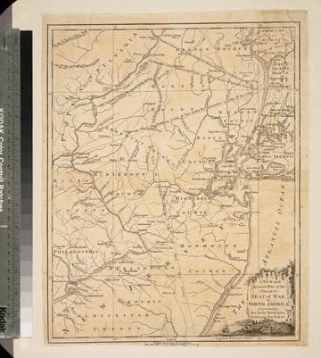
New and Accurate Map of the Present Seat of War in North America, Comprehending New Jersey, Philadelphia, Pensylvania (sic), New-York &c
Visual Materials
Kashnor dates as c.1770. Probably later because of reference to Revolutionary War. Some notes regarding boundary dispute between New York and New Jersey. Small vined cartouche with sailing ship. MS note: 101 (on backing). Prime meridian: London. Relief: pictorial. Graphic Scale: Miles, statute. Projection: Cylindrical. Watermark: Crowned seal. Printing Process: Copper engraving. Other Features: Cartouche. Verso Text: MS note: 410 (map) 101 (on backing).
093:101 S
Image not available
Survey of Land in Falls Township and of Goat Island adjoining the Delaware River. Also: second survey of same
Manuscripts
The bulk of the collection consists of correspondence, legal instruments, plans, surveys, appraisals, accounts and other documents related to the Growden legacy; including the shares in Durham Iron Works, the properties in Durham, Bensalem, and Richland Townships, an upper lot of the Delaware River, and houses in Philadelphia. The materials cover the 1773 partition of the Growden's estates and their fate after Pennsylvania Act of Attainder (1778) and the death of Joseph Galloway. Correspondents include: Joseph Galloway, his brother-in-law Thomas Nickelson and their Philadelphia representatives Abel James and John Thompson; Nickelson's sons-in-law Ellis Button Metford and John Jeffery; Grace Galloway's granddaughter Ann Grace Roberts Burton. John Thompson's grandson John James Thompson (1815-1875), and others.
HM 36894 (a & b)