Manuscripts
Jonathan Harrison map of the land between the Delaware and Susquehanna Rivers, with Indian towns and trails identified
You might also be interested in

Jonathan Harrison map of the land between the Delaware and Susquehanna Rivers, with Indian towns and trails identified
Manuscripts
A manuscript map related to the boundary dispute between New York and New Jersey. Shows land between the upper Delaware River and the Upper Susquehanna River.
mssWalking
Image not available
Nicholas Scull map of the fork of the Delaware River
Manuscripts
This manuscript map was probably drawn for a 1732 deed.
mssWalking
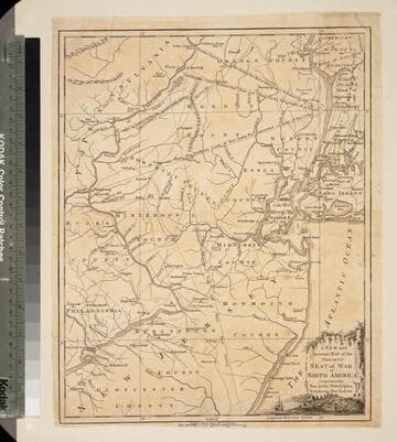
New and Accurate Map of the Present Seat of War in North America, Comprehending New Jersey, Philadelphia, Pensylvania (sic), New-York &c
Visual Materials
Kashnor dates as c.1770. Probably later because of reference to Revolutionary War. Some notes regarding boundary dispute between New York and New Jersey. Small vined cartouche with sailing ship. MS note: 101 (on backing). Prime meridian: London. Relief: pictorial. Graphic Scale: Miles, statute. Projection: Cylindrical. Watermark: Crowned seal. Printing Process: Copper engraving. Other Features: Cartouche. Verso Text: MS note: 410 (map) 101 (on backing).
093:101 S
![A map of the province of New-York & part of New Jersey [cartographic material]](/_next/image?url=https%3A%2F%2Frail.huntington.org%2FIIIF3%2FImage%2F22APN4MO8RID%2Ffull%2F%5E360%2C%2F0%2Fdefault.jpg&w=750&q=75)
A map of the province of New-York & part of New Jersey [cartographic material]
Manuscripts
Manuscript map by Charles Rivez, showing the boundaries between the provinces of New York and New Jersey. The Hudson and Mohawk rivers are well defined, and the forts, towns and settlements along them are depicted. Lake George and the territory to the north of Ticonderoga are shown, and the settlements, towns and roads of New Jersey are shown through the northern part of Burlington county.
mssHM 15453

Map of the portion of the Country in dispute with the United States including the Plain that separates the Highlands of the Treaty of 1783 in which the latter Highlands, the Northwesternmost head of the Connecticut River takes its rise
Visual Materials
Includes sectional elevation view from first lake on Connecticut River to River Oulle (which drains to the St. Lawrence River). Current boundary area between northern Maine and Quebec. Submap of wider area of dispute. Reduced map embracing the territory in dispute.. Prime meridian: London. Relief: hachures. Projection: Plane. Printing Process: Copper engraving. Other Features: Sub-maps. Verso Text: MS note: 140.
093:140 S
Image not available
Excerpt from the minutes of the Indian council at Philadelphia…between Governor Patrick Gordon and the Chiefs of the Delaware and Shawnee, regarding Susquehannah River lands
Manuscripts
Excerpts from the minutes of the 1728 treaty council convened to deal with unauthorized settlements in the Delaware lands.
mssWalking