Rare Books
Lewis Evans : his map of the Middle British Colonies in America : a comparative account of eighteen different editions published between 1755 and 1814
Image not available
You might also be interested in
Image not available
Speedily will be published, (sold by J. Almon, ... a map of the middle British colonies in North-America. First published by Mr. Lewis Evans, ... in 1755; and since corrected and improved, ... By T. Pownall, ... With a topographical description of such parts of North-America as are contained in the map
Rare Books
86034
Image not available
The Middle line: or, An attempt to furnish some hints for ending the differences subsisting between Great-Britain and the colonies
Rare Books
9305

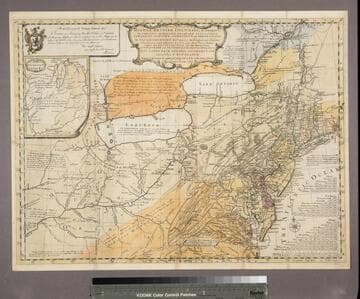
A map of the middle British Colonies, in North America : first published by Mr. Lewis Evans, of Philadelphia, in 1755 ; and since corrected and improved, as also extended, with the addition of New England, and bordering parts of Canada ; from actual surveys now lying at the Board of Trade / By T. Pownall MP ; with a topographical description of such parts of North America as are contained in this map. Printed and published according to Act of Parliament for J. Almon in Piccadilly, London, March 25th. 1776
Rare Books
Pownall reissued Evans 1755 map with new title and many alterations particularly in the Eastern Section. This map was meant to be published with a new extension (see 18224). This is probably a proof copy of the altered plate before the extension was added. Submap: A sketch of the Remaining part of the Ohio R., &c. MS note: 18223. Prime meridian: London, Philadelphia. Relief: pictorial. Graphic Scale: Miles. Projection: Pseudocylindrical. Printing Process: Copper engraving. Verso Text: Stamped: XII. MS notes: Shelve with #18212 Evans, Lewis ; #18223.
18223

A map of the middle British Colonies in North America, first published by Mr. Lewis Evans, of Philadelphia, in 1755 ; and since corrected and improved, as also extended, with the addition of New England, and bordering parts of Canada ; from actual surveys now lying at the Board of Trade / by T. Pownall MP, with a topographical description of such parts of North America as are contained in this map. Printed & published according to Act of Parliament for J. Almon in Piccadilly, London, March 25th 1776
Rare Books
Pownall reissued Evans 1755 map with new title and many alterations particularly in the Eastern Section, see 18223. It now is completed with an eastern extension by Pownall pasted onto the original map. Pownall also adds counties and townships of some states in the blank sections of this extension. Submap: A sketch of the Remaining part of the Ohio R., &c. MS note: 18224. Prime meridian: London, Philadelphia. Relief: pictorial. Graphic Scale: Miles. Projection: Pseudocylindrical. Printing Process: Copper engraving. Verso Text: Stamped: XIII. MS notes: Shelve with #18212 Evans, Lewis ; #18224.
18224

Bowles's new pocket map of the middle British Colonies, in America : viz. Virginia, Maryland, Delaware, Pensylvania, New Jersey, New York, Connecticut & Rhode Island ; comprending also the habitations & hunting countries of the Confederate Indians / by Lewis Evans. Printed for the proprietor Carington Bowles, No. 69 in St. Pauls Church Yard, London
Rare Books
This map is the same as 18219 with alteration of the title. Appears in "Bowles's Universal Atlas" undated, but with other maps dated 1780. It must have been issued before the Peace of 1782-3. Lake Huron extended northward, some streams added above Lakes Ontario and Erie, legend above Lake Erie removed. Submap: A sketch of the Remaining part of the Ohio R., &c. MS note: 18227. Prime meridian: London, Philadelphia. Relief: pictorial. Graphic Scale: Miles. Projection: Pseudocylindrical. Printing Process: Copper engraving. Verso Text: Stamped: XVI. MS notes: Shelve with #18212 Evans, Lewis ; #18227.
18227
A general map of the middle British Colonies, in America; viz Virginia, Màriland, Dèlaware, Pensilvania, New-Jersey, New-York, Connecticut, and Rhode Island: of Aquanishuonîgy, the country of the Confederate Indians; comprehending Aquanishounîgy proper, their place of residence, Ohio and Tïiuxsoxrúntie their deer-hunting countries, Couxsaxráge and Skaniadaráde, their beaver-hunting countries; of the Lakes Erie, Ontário and Champlain, and of part of New-France: wherein is also shewn the antient and present seats of the Indian Nations / by Lewis Evans 1755
Rare Books
Evans 1755 map is now landscape and includes more westerly parts of North America. A submap extends the course of the Ohio River to the Mississippi. Evans notes Fry and Jefferson's map of Virginia and notes agreement of Longitudinal observations with Thomas Godfrey. The "Analysis" referred to is a 32 page quarto written by Evans and printed by B. Franklin and D. Hall at Philadelphia in 1755 describing the country and boundaries. This map normally accompanied that publication. A copy of the Analysis accompanies the maps in the same folder, along with a copy of Pownall's 1776 "Topographical Description of North America." Submap: A sketch of the Remaining part of the Ohio R., &c. MS note: 18213. Prime meridian: London, Philadelphia. Relief: pictorial. Graphic Scale: Miles. Projection: Pseudocylindrical. Printing Process: Copper engraving. Verso Text: Stamped: II. MS notes: Shelve with #18212 Evans, Lewis ; #18213.
18213