Books
Shore ecology of the Gulf of Mexico
Image not available
You might also be interested in
Image not available
Map of Ocean Shore Lands, Sutro Baths & Museum and Sutro Heights
Rare Books
"Proposition to acquire Sutro Properties to be voted on Dec. 20th Number One on ballot." Date obtained from San Francisco municipal reports. Two identical maps on one sheet, prepared for an election to acquire property at the north west corner of San Francisco. MS note: 372937. Prime meridian: GM. Relief: no. Projection: Plane. Printing Process: Lithography.
372937

A General Chart of the West Indies and Gulf of Mexico
Visual Materials
Kashnor notes, "Shows a good coastline to present-day Texas." Submaps of the Virgin Islands and Panama. See also 093:719. Submaps: Chart of the Virgin Islands; Chart of the Coast of Biruquete, Panama, and Veragua, from Point Solano to Point Burica.. "describing the Gulf and Windward Passages, Coasts of Florida, Louisiana and Mexico, Bay of Honduras and Musquito Shore; likewise the Coast of the Spanish Main to the Mouths of the Orinoco. Drawn fro the Surveys taken by Mr. Geo. Gaulo and others. The New Spanish Charts, &c. and adjusted from recent Observations, J. Foss Dessiou, Master of the Royal Navy. Approved by the Chart Committee of the Admiralty." Prime meridian: London. Relief: no. Projection: Cylindrical. Printing Process: Copper engraving. Other Features: Sub-maps. Verso Text: MS notes: 796 4 sheets 19.
105:796 M
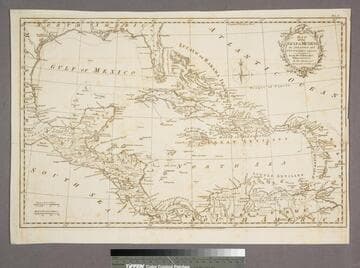
Map of the Gulf of Mexico, the Islands and Countries adjacent
Visual Materials
"For the Rev. Dr. Robertson's History of America. By Thos. Kitchin Senr. Hydrographer to his Majesty." "Vol. I (upper right)" Cartouche: leafy boughs.. Prime meridian: Ferro. Relief: pictorial. Graphic Scale: Miles, leagues. Projection: Polar. Printing Process: Copper engraving. Other Features: Cartouche. Verso Text: MS note: 955.
105:955 S