Visual Materials
Columbia, southern mines, California
Image not available
You might also be interested in

Jackson, Amador Co
Rare Books
Image contains three general views. The upper view is of the town of Jackson, the lower left view is of Butte Cuty, and the lower right view is of The Gate. "Printed by Britton & Rey. Published by Wesly Jackson, Jackson News Depot. From Nature & on Stone by Kuchel & Dresel, 146 Clay St. S. F."--text, below image. Paper color: gray.
48052:124
Image not available
Yankee Jims', Placer County, California, 1857
Rare Books
Scott & Brother were bankers in Yankee Jims'. "Britton & Rey print." "Drawn from nature & lithd by Kuchel & Dresel, San Francisco." At head of lithograph: Kuchel & Dresel's California views. Vignettes: 12 vignettes of homes and businesses. MS note: 183632. Prime meridian: GM. Projection: Birds-eye view. Printing Process: Lithography. Other Features: Vignettes.
183632
Image not available
The only correct and reliable Map of the Washoe Mining Region with relative distances from the principal places of California. The claims are located by Parker H. Pierce Recorder of Carson City. Designed and drawn by R. M. Evans. Together with Evans' Travellers Guide
Rare Books
Map and guide are folded into a single cover, submap is also glued in the same cover. The Nevada Territory itself did not exist until 1861; the Comstock Lode, which appears on the map, was discovered in 1859. Submap: Map of the Overland Route. On submap: "Kuchel & Dresel lith.176 Clay St. S.F." Prime meridian: GM. Relief: shaded, hachures. Graphic Scale: Miles. Projection: Cylindrical. Printing Process: Lithography.
7011

Map of the Mining Region of California. 1854
Rare Books
Image of a map from Oregon border to Monterey and Tulare Counties, and from the Pacific Coast to the Utah desert. In the upper right corner is a "Table of Distances from the Capital." On the right side is a list of the population of California and several cities. "Drawn & Compiled by Geo H. Baker. Published by Barber & Baker, Sacramento, Cal. Fishbourne's Lithog. San Francisco, Cal."--text, below map title. "Entered According to Act of Congress, in the Year 1854, by Barber & Baker, in the Clerks Office of the District Court of the United States, for the Northern District of California. Fishbourne Lithogy. California."--text, below image. "Noisy Carriers, San Francisco."--stamped text, above image. Paper color: blue.
48052:060
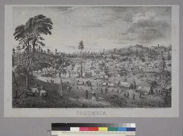
Columbia January, 1852
Rare Books
Image is of a town in a forest setting with hills in the background. There are people engaged in various activities or taking their leisure on the hillside in the foreground. The main street of the town can be seen at the right center. "G. H. Goddard del. Entered according to act of Congress in the year 1852 by G. H. Goddard in the Clerks Office of the Dist. Court of the Northern Dist. of California. Pollard & Britton's Lith, Merchant Str. S. F."--text, below image. Paper color: gray.
48052:192
![[Untitled. Baird title:<Mining scene>]](/_next/image?url=https%3A%2F%2Frail.huntington.org%2FIIIF3%2FImage%2F22APN4KQGBN1%2Ffull%2F%5E360%2C%2F0%2Fdefault.jpg&w=750&q=75)
[Untitled. Baird title:<Mining scene>]
Rare Books
Image is of five miners working a sluice box while one rests. Cabins and forest are in the background. The mirror image of "E.C.R" is in the lower right corner of the image. "Published by Chas. P. Kimball, Noisy Carriers' Publishing Hall, San Francisco, Cal."--text, below image. Paper color: gray.
48052:017