Opening Hours
Daily: 10 A.M.–5 P.M.
Closed on Tuesdays
1151 Oxford Road
San Marino, CA 91108
Visual Materials
Daily: 10 A.M.–5 P.M.
Closed on Tuesdays
1151 Oxford Road
San Marino, CA 91108

Image not available
Rare Books
"The best for least." "Perris, California 1889 Farm Lands 15 to 30 dollars per acre." Vignettes: Eight residences and businesses in the surround. Prime meridian: GM. Relief: hachures. Graphic Scale: Sections. Projection: Cylindrical. Printing Process: Lithography. Verso Text: MS notes: Map of Perris Calif 1890 from the F. E. Brown family files.
354818
Visual Materials
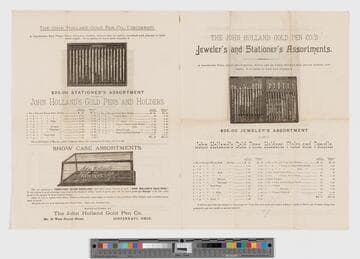
Image of a single-fold advertisement for assorted pens, holders, toothpicks, pencils, and cases sold by the John Holland Gold Pen Company of Cincinnati, Ohio; images of various assortments of pens in cases interspersed with descriptive text and pricing information.
priJLC_FASH_Hunt_003664
Visual Materials
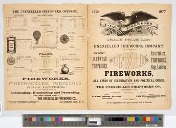
Image of a leaflet listing pricing information about different types of fireworks, firecrackers, and goods for sale by the Unexcelled Fireworks Company in New York. Print was folded, with four printed pages total, two on verso and two on recto. Right page of recto includes the title and a vignette similar to imagery on the Great Seal of the United States. Includes an image of an American eagle holding up a banner labeled “UnXld Fireworks” in its beak. Below the eagle is a shield with American stripes and stars, and the eagle holds an olive branch with one talon, and arrows with another. Left page of recto includes pricing information and five vignettes of lanterns, balloons, fireworks, and bomb shells. Verso pages include five vignettes of fireworks and rockets and lists the various names, descriptions, and pricing information about materials for sale, ranging from “Roman Candles” to “Torpedoes.”
priJLC_SPO_005000
Image not available
Visual Materials
Perhaps the most famous and admired pictorial map of California ever made. Jo Mora surrounded his map with vignettes and figures depicting the history and fantasy of California. This 1927 prohibition era shows bootleggers offshore Monterey, and Owens Valley residents kicking holes in the new Los Angeles aqueduct. A tour de force of boosterism seldom equaled, never bested. Many vignettes in the surround and characters on the map itself. Prime meridian: GM. Relief: pictorial. Projection: Cylindrical. Printing Process: Lithography.
priJHK 00674
Image not available
Rare Books
Originally issued in volume 2 (plate 42) of Atlas Historique, Ou Nouvelle Introduction A l'Histoire, à la Chronologie et à la Géographie Ancienne et Moderne. Published by l'Honoré & Châtelain in 1720. Map depicts a historical view of Britain and Ireland, drawing primarily on Caesar, but including information as late as the 5th century. Inset map is of the Saxon kingdoms. A summary of the known early history of the British Isles with portraits of rulers in the surround, ending with Anne in 1702. Vignettes: Rulers, descriptive information on history. "Tome 2, No. 42" Prime meridian: GM. Relief: no. Projection: Cylindrical. Printing Process: Copper engraving.
210142
Visual Materials
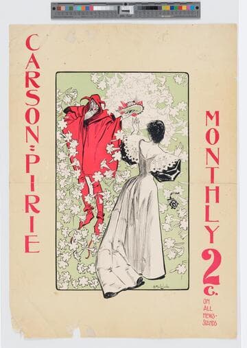
Image of an advertisement for Carson Pirie Monthly periodical; a woman in a long elegant dress stands facing the devil, who offers her a hat in his outstretched hand as she drops her book with a cross on the cover; flowers surround the two figures.
priJLC_ART_003120