Visual Materials
Map of Bethlehem and the new town of Wetherill, Northampton county, Pa
You might also be interested in
Image not available
Map of Bethlehem and the new town of Wetherill, Northampton county, Pa
Visual Materials
Artist/Author: Roepper, W. Th. (William Theodore). Printer: P.S. Duval & Co., Philadelphia (Pa.).
priJLC_TRAV_006073
Image not available
Fresno County California, Perrin colonies
Visual Materials
Image of a promotional map advertising colonies in Fresno, California by real estate broker Dr. E.B. [Edward, Burt] Perrin. The map is printed on both sides and opens up to two pages of text, with four printed pages total. The front page is titled “Fresno County California, Perrin Colonies,” in a red decorative ribbon. Above the ribbon are two vignettes of views in Fresno. The view on the left is titled, “Orange Grove Farm. 7 miles NE of Sanger, on the Kings River. Property of Joseph Burns.” The vignette on the top right is titled, “Caledonia Vineyard, Fresno. Alex Gordon.” To the right of the title is an image of green grapes with text that reads, “A Bunch of Fresno Co. Grapes.” Below the title are inset cadastral maps of Perrin Colonies 2, 4, and 5. Also shown is an inset map showing 10 acres of raisin vineyards. Near the maps is text that reads, “Compliments of Vincent, Chittenden, Cole, Sharp & Gordon, 113 1 Street, Fresno, Cal.” The bottom of the print includes four more vignettes decorated around ribbons and grapevines. The vignette on the left corner is an inset map of California with a finger shown pointing at Fresno, which is colored in blue. Other vignettes include an image of hanging grapes titled, “Grapes Raised by B.F. Moore,” orange groves titled, “Fulton c. Berry’s Orange Trees. Fresno, Co.,” and a view of Fresno City. Opposite the cover of the flyer (the back page of the foldable flyer) is a cadastral map of Fresno. In red coloring, the map indicates properties owned by Dr. Perrin and others, and shows properties marked Perrin Colony 1-5. Also in red is a region titled Rancho Laguna de Tache. Relief on the map is shown with hachures. The verso (interior pages of foldable flyer) includes printed text in eight columns headlined, “What the Fresno County Board of Trade Say,” and was published by the Consent of Fresno County Board of Trade, Fresno, California. S.H. Cole is listed as secretary, and Thomas E. Hughes is listed as President. The text promotes properties in Fresno and provides facts about farming, agricultural products, climate, health, vineyards, government, grapes, and raisin industries within the city.
priJLC_TRAV_006076
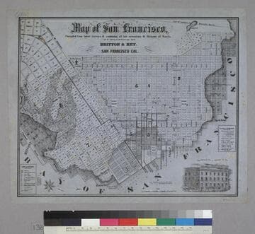
Map of San Francisco
Rare Books
Image is of a map of the downtown area with a vignette of Parrott Block in the lower right corner. The map covers the area from waterfront to Webster, and from North Point to Addition of Mission. At the lower left are nine letter identifications of public buildings on the map and symbols for other locations. At the right are twelve letter identifications for places of worship. "Published by Britton & Rey, San Francisco Cal."--text, below title of map. "Page Bacon & Co. Adams & Co."--text, above vignette in lower right corner. Paper color: blue.
48052:138
APL World cruise map
Visual Materials
Along right side of map is space to right out a travel itinerary, and below it a graphic of APL vessel stack; map was once folded and the right side would form the back and front covers of the folded map. "ADV WM2 100M 10-58"--text, small type, in space between itinerary and graphic. "[1958/9]"--in ms., in pencil, lower right corner.
priJHK 00117

A map showing the network of European railroads
Visual Materials
"[Affixed label for D.F. Robertson Travel Insurance] through all Europe from Paris ... via French National Railroads"--text box with an image of the Eiffle Tower and train, the outline of France in green in the background, upper right corner of the map. "Printed in U.S.A., Z.J. Kantin Company, N.Y."--text, small type, lower left corner, below image. "Specially prepared by the French National Railroads / offered to travel agents — A.S.T.A. Convention — 1949"--text, lower right corner, below image. Two labels for D.F. Robertson Travel Insurance, Los Angeles, are affixed to the map, one along the lower edge, the other in blank space left for an agent's, or agencies, stamp in the upper right corner of the map within the inset text box.
priJHK 00118
Image not available
The Town of San Fernando
Rare Books
The building in the upper right corner may be Maclay College. It is inscribed "EL Cantin Eng. Co. Los A." Sales description down the right side. The Southern Pacific tracks exist along with many of the street names shown. Note indicates this as a gift of Mrs. Catherine Dace, May 1938. See map 233034 for a wider view of this area, 233033 for a later addition. " For information apply to Phillips & Waite, 136. N. Main Street, or H. W. Griswold, San Fernando." Relief: no. Graphic Scale: Feet. Projection: Plane. Printing Process: Lithography. Verso Text: MS note: 233038.
233038