Visual Materials
Travellers' guide through the United States, showing the principal routes by railroad, steamboat, canal & stage

You might also be interested in
Image not available
Traveller's Map of the Middle, Northern, Eastern States and Canada. Showing all the Railroad, Steamboat, Canal and Principal Stage Routes
Rare Books
Vignette of Niagara Falls and River. Vignette: Niagara River and surrounding country showing the proposed ship canal, Rail Roads, etc. Drawn by the late Captain W. G. Williams, U.S. Topographical Corps. Prime meridian: GM, Washington. Relief: no. Graphic Scale: Miles. Projection: Polyconic. Printing Process: Lithography.
304292

Great western and south western U.S. Mail Route. New York and Erie broad gauge railroad ... (New York, May, 1855.)
Visual Materials
Image of a broadside with text advertising the routes of the New York and Erie Railroad; wood-engraved vignette of a steam locomotive, tender, and cars in a rural setting centered in the upper half of the poster and a wood-engraved vignette of a steamship centered in the lower half of the poster.
priJLC_TRAN_001094

Old colony line via Middleboro' and Woods Holl, to Oak Bluffs Martha's Vineyard and Nantucket : the famous seaside resorts of America ... Boston, June 23, 1877
Visual Materials
Image of a wood-engraved vignette of a steam locomotive and tender labeled "Old Colony" on railroad tracks next to a dock with waiting passengers and a horse-drawn wagon, and a sailboat and steamboat, the Island Home, in the water, centered in a broadside with text promoting the Old Colony Railroad route to Martha's Vineyard and Nantucket, Massachusetts, with printed timetables and promotional text, and a bottom center wood-engraved map of New England with railroad routes.
priJLC_TRAN_001089

Great Eastern rail road route over Massachusetts western rail road, from Albany or Troy for Boston
Visual Materials
Image of a broadside advertising the route of the Great Eastern Railroad with a wood-engraved vignette of a steam locomotive, with a 4-4-0 wheel arrangement, tender, and a freight car and passenger car centered in the upper third of the poster; decorated border.
priJLC_TRAN_001095

Map of the great air line route, Ohio & Mississippi Railway and connections
Visual Materials
Image of a map of a portion of the Eastern and Midwestern United States from as far west as Denver, Colorado, to the Atlantic Ocean, showing the railroad route of the Ohio & Mississippi Railroad and connecting lines; with a vignette of the East Bridge captioned "View of the bridge across the Mississippi at St. Louis." and printed information about the bridge to the left of map; map verso contains panels with the fold-up map covers, promotional descriptions, timetables, a vignette of the East Bridge with a steamboat and horse-drawn wagons and pedestrians in the foreground, and a vignette of a side elevation of a Pullman drawing room and sleeping car.
priJLC_TRAN_001170
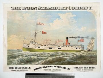
The Union Steamboat Company
Visual Materials
Image of the steamboat St. Louis sailing with a sailboat nearby and other vessels in the distance; American flag and pennants that read "St. Louis," "U.S. Co.," "Detroit," "Buffalo," "Portage," and "Marquette" stream in the wind; arched sign on side of vessel reads, "The Union Steamboat Co. Erie Railway Line."
priJLC_MAR_002607