Visual Materials
Map of the state of California : showing the new line of the California Pacific Rail Road Co. and the rail road system of the state

You might also be interested in

Map showing St. Louis and Memphis Rail Road
Visual Materials
Image of a map of a portion of the middle United States showing both completed and proposed railroad lines including the projected line of the St. Louis and Memphis Railroad between Morley, Missouri, and Memphis, Tennessee.
priJLC_TRAN_001148

Map of the New York Central and Hudson River Rail Road and its principal connections
Visual Materials
Image of a map of the Eastern United States showing the railroad routes of the New York Central and Hudson River Railroad and connecting lines from Boston, Massachusetts, to St. Paul, Minnesota, and New Orleans, Louisiana; map verso has fold-up map covers, promotional descriptions, and timetables.
priJLC_TRAN_001147
Colton's map of the United States, the Canadas &c showing the rail roads, canals & stage roads with distances from place to place
Rare Books
Kirkpatrick Catalogue entry: "2463 Colton, J. H., publisher. Colton's map of the United States, the Canadas &c. showing the rail roads, canals, & stage roads ... New York, J. H. Colton, 1860. 1 sheet. [see p.]."Alternate title from cover. Submaps: Map of New England and Eastern New York; Map of the United States & Central America; The Isthmus of Panama showing the Routes of Travel between Aspinwall & Panama. . Prime meridian: GM, Washington. Relief: hachures. Graphic Scale: Miles. Projection: Polyconic. Printing Process: Lithography. Other Features: Sub-maps. Verso Text: MS note: R.B. 11486, i Stamp: Kensington Public Libraries.
623637

Map of the New York Central and Hudson River Rail Road and its principal connections
Visual Materials
Image of a map of a portion of the Eastern and Midwestern United States from as far west as Omaha, Nebraska, to the Atlantic Ocean, showing the railroad routes of the New York Central and Hudson River Railroad and connecting lines, with a vignette of the seal of New York with the banner "Excelsior" above the map title; map verso contains fold-up map cover with a vignette of a passenger train car labeled "Wagners Palace Drawing Room Car" and panels with promotional descriptions and timetables.
priJLC_TRAN_001171

New map of our country from the Atlantic to Kansas and the Pacific ... 1871
Visual Materials
Image of a coast-to-coast map of the middle portion of the United States showing the railroad routes of the Hannibal & St. Joseph Railroad and connecting lines from Quincy, Illinois, to San Francisco, California; map verso contains fold-up map covers and panels with promotional descriptions and timetables.
priJLC_TRAN_001106
Image not available
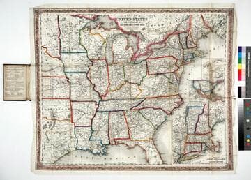
A new map for travelers through the United States of America : showing the railroads, canals and stage roads with the distances / by J. Calvin Smith
Rare Books
Alternate title from cover. Gift of Mr. & Mrs. Robert P. Hastings September 1975. Submaps: Map of Oregon Northern California Santa Fe &c.; Map showing the Rail Roads between the Cities of New York, Boston & Albany, and the Hudson R. from New York to Albany; Railroad Route from New York to Philadelphia; Railroad and Canal routes from Albany to Buffalo. Prime meridian: Washington. Relief: no. Graphic Scale: Miles. Projection: Polyconic. Printing Process: Lithography.
442530