Visual Materials
Map of Indian territory and Oklahoma : 1890

You might also be interested in

Map showing the railroad connections of the Indian territory
Visual Materials
Image of page 777 of the February 24, 1879, issue of the Daily Graphic newspaper containing a newspaper article with a map showing the railroad lines in Indian territory and surrounding states including Kansas, Missouri, Illinois, Arkansas, and Texas; accompanied by images on page 776 captioned "Issuing soup tickets in Windmill Street. / The Distress in Manchester, England." and "A Kaffir War Dance. / The War in South Africa."
priJLC_TRAN_001143

Map of the Texas & Pacific Railway and connections. : The true Southern route to and from California is via El Paso and the Texas & Pacific Railway
Visual Materials
Image of a map of Texas and bordering states showing the route and connecting lines of the Texas & Pacific Railway, with an inset map in the upper right corner of most of the continental United States, Mexico, and Cuba, and an inset in the lower right corner of a black and white photograph captioned, “Harvest scene on line of the Texas & Pacific Railway in Texas,” with men on mule-driven farm equipment in a field; map verso contains panels with fold-up map covers, railroad timetables and promotional descriptions.
priJLC_TRAN_001060

Map of the Northern Pacific Railway and tributary country
Visual Materials
Image of a map of the routes and connecting lines of the Northern Pacific Railway across the northern United States and Canada; inset circular map of the northern hemisphere in the upper right corner and a diagram in the bottom margin of the elevations of the routes of the Northern Pacific Railroad and the Union Pacific Railroad.
priJLC_TRAN_001052
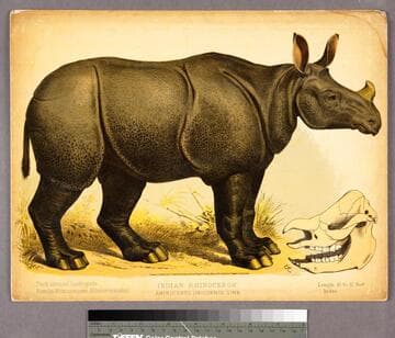
Indian rhinoceros
Visual Materials
Image of a side view of an Indian rhinoceros; image of rhino skull inset at bottom right.
priJLC_PRG_002216

Rand, McNally & Co.'s California
Visual Materials
Image of a map of California with railroad routes shown; inset in the bottom left corner of Southern California from Los Angeles to San Diego and an inset in the upper right corner of the San Francisco area; reference key for 37 railroads printed in red and titled "California Railroads." A key of "California. / Chief Cities" with populations printed in left margin.
priJLC_TRAN_001102

The short line across the continent. : Map of the great central route between the Atlantic and Pacific : Michigan Central and Great Western Railways
Visual Materials
Image of a map of a portion of the Eastern United States from as far west as Omaha, Nebraska, showing railroad routes of the Michigan Central and Great Western Railroad and connecting lines, with a vignette in the lower left corner of the Niagara Falls Suspension Bridge and an inset map in the lower right corner of the Western United States showing railroad routes and titled, "Map between the Missouri River and the Pacific Ocean"; map verso contains panels with the fold-up map covers, promotional descriptions including an image of a freight car for the Great Central Route's Blue Line, and timetables.
priJLC_TRAN_001174