Visual Materials
A new chart of the seas surrounding the island of Cuba : with the soundings, currents, ships courses &c and a map of the island itself lately made by an officer in the Navy

You might also be interested in

A new map of the island of Jamaica : divided into its parishes including the south end of Cuba and the west end of Hispaniola with the trade winds &c / drawn from the best surveys by Thos. Kitchin Geogr
Visual Materials
Two submaps. Kashnor dates as ca. 1780. Jolly notes London Magazine publication date as July 1763. Duplicate of 105:461. Submaps: Chart of the Windward Passage; Plan of Port Royal Harbour. MS note: 461 (on backing). Prime meridian: London. Relief: pictorial. Graphic Scale: Miles. Projection: Cylindrical. Printing Process: Copper engraving. Other Features: Sub-maps. References: Jolly Brit. Period. LOND-228.
105:460 M

New Map of the Island of Jamaica Divided into its Parishes Including the South End of Cuba and the West End of Hispaniola with the Trade Winds &c. Drawn from the best Surveys by Thos. Kitchin Geogr
Visual Materials
Two submaps. Kashnor dates as ca. 1780. Jolly notes London Magazine publication date as July 1763. Duplicate of 105:460. Submaps: Chart of the Windward Passage; Plan of Port Royal Harbour. MS note: 460 (on backing). Prime meridian: London. Relief: pictorial. Graphic Scale: Miles. Projection: Cylindrical. Printing Process: Copper engraving. Other Features: Sub-maps. References: Jolly Brit. Period. LOND-228.
105:461 M
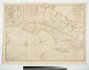
A New & Correct Chart of Cuba, Streights of Bahama, Windward Passage, the Current through the Gulf of Florida, with the Soundings &c. By an Officer in the Navy
Visual Materials
Kashnor dates as ca. 1740. Sub-map: A Plan of the Harbour & Town of Havana. Prime meridian: London. Relief: pictorial. Projection: Mercator. Printing Process: Copper engraving. Other Features: Sub-maps. Verso Text: MS note: 381.
105:381 M

A Chart of the Island of Jamaica, with its Bays, Harbours, Rocks, Soundings, &c
Visual Materials
MS note: 454 (on backing). Prime meridian: London. Relief: pictorial. Graphic Scale: Miles. Projection: Cylindrical. Watermark: Britannia Seal. Printing Process: Copper engraving.
105:454 S
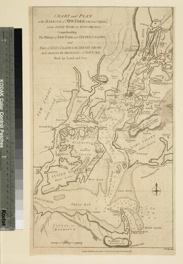
Chart and Plan of the Harbour of New York & the Couny. Adjacent, from Sandy Hook to Kingsbridge, Comprehending the Whole of New York and Staten Islands, and Part of Long Island & the Jersey Shore: And shewing the Defences of New York Both by Land and Sea
Visual Materials
Shows sites of important military engagements. MS note: 119 (on backing). Relief: hachures. Graphic Scale: Miles. Projection: Plane. Watermark: VI. Printing Process: Copper engraving. References: Haskell, D. C. 534; Phillips p.528..
105:119 S
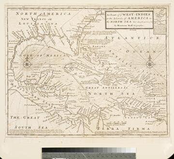
Chart of the West Indies or the Islands of America in the North Sea &c. Being the Present Seat of War. by Herman Moll Geographer
Visual Materials
Kashnor notes, "Shows the mainland around the Gulf of Mexico, with Louisiana, Florida, Georgia, and Carolina." Kashnor dates as ca. 1719. Submap: Vera Cruz harbor. Sailing instructions for galleons. MS note: 321 (on backing). Prime meridian: London. Relief: no. Projection: Cylindrical. Watermark: Two devices. Printing Process: Copper engraving. Other Features: Sub-maps.
105:321 S