Visual Materials
North Carolina from the Latest Surveys, by Samuel Lewis
You might also be interested in

Map of Martinico, from the latest and best Authorities
Visual Materials
Kashnor dates as ca. 1759. Submap: Map of that part of Guadaloupe, where the English made their Descent, Jany. 23 1759. MS note: 818 (on backing). Prime meridian: London. Relief: hachures. Graphic Scale: Miles. Projection: Cylindrical. Printing Process: Copper engraving. Other Features: Sub-maps. Verso Text: MS note: 818 (on backing).
093:818 S
Image not available
The State of New Hampshire. Compiled chiefly from Actual Surveys By Samuel Lewis, 1813
Visual Materials
Kashnor states [Philadelphia, 1818]. Prime meridian: London, Philadelphia. Relief: pictorial. Graphic Scale: Miles. Projection: Cylindrical. Printing Process: Copper engraving. Verso Text: MS notes: 539.
105:539 S
Image not available
[Map of the Eastern Coast from Labrador to Carolina]
Visual Materials
Kashnor notes, "A rare early map issued without title, probably by Schenk or Gerald Valck. It is very valuable for the locations of the old colonies on the seaboard, and particularly of Carolina, where North Carolina is called "Vielle Virginie," though locating the counties of Albermarle and Clarendon." Two submaps. Kashnor dates as ca. 1700. Submap: Mississippi delta; coast of Louisiana eastward. MS note:05. Relief: pictorial. Graphic Scale: Miles, leagues. Projection: Cylindrical. Printing Process: Copper engraving. Other Features: Sub-maps. Verso Text: MS notes: 327 n.J.
105:327 M
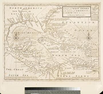
Chart of the West Indies or the Islands of America in the North Sea &c. Being the Present Seat of War. by Herman Moll Geographer
Visual Materials
Kashnor notes, "Shows the mainland around the Gulf of Mexico, with Louisiana, Florida, Georgia, and Carolina." Kashnor dates as ca. 1719. Submap: Vera Cruz harbor. Sailing instructions for galleons. MS note: 321 (on backing). Prime meridian: London. Relief: no. Projection: Cylindrical. Watermark: Two devices. Printing Process: Copper engraving. Other Features: Sub-maps.
105:321 S
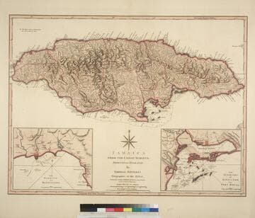
Jamaica from the latest surveys; Improved and Engraved by Thomas Jefferys Geographer to the King
Visual Materials
Two insert maps.See also 093:796M for a later version. Submap: Harbour of Bluefields; Harbour of Kingston aand Port Royal.. Prime meridian: London, Ferro. Relief: hachures. Graphic Scale: Miles, leagues. Projection: Cylindrical. Printing Process: Copper engraving. Other Features: Sub-maps. Verso Text: MS note: 795.
093:795 M

Jamaica from the latest surveys; Improved and Engraved by Thomas Jefferys Geographer to the King
Visual Materials
Two insert maps. See also 093:795M for an earlier version. Submap: Anchorage at Savanna la Mar & Bluefields; Harbour of Kingston aand Port Royal.. Prime meridian: GM. Relief: hachures. Graphic Scale: Miles, leagues. Projection: Cylindrical. Printing Process: Copper engraving. Other Features: Sub-maps. Verso Text: MS note: 796.
093:796 M