Visual Materials
[Map of the Eastern Coast from Labrador to Carolina]
You might also be interested in
Image not available
A New Map of Carolina
Visual Materials
Kashnor notes, "An important map, showing the exact state of the settlements in Carolina at the close of the XVII century. The inset map of Ashley River shows the names and locations of thirty-seven settlers." Kashnor dates as ca. 1680. Submap: A particular map for going into Ashley and Cooper Rivers. Table lists 33 settlers.. Prime meridian: London. Relief: pictorial. Graphic Scale: Miles. Projection: Cylindrical. Watermark: KO?. Printing Process: Copper engraving. Other Features: Sub-maps. Verso Text: MS notes: 96 105:336.
105:336 M
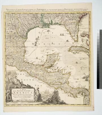
Map of the British Empire in America With the French, Spanish and the Dutch Settlements adjacent thereto by Henry Popple
Visual Materials
Kashnor notes, "Copied from Popple's map With the titles in English and French. ShoWs Carolina divided into counites, With Georgia and the Forts neWly erected, and Savannah." Kashnor dates as ca. 1740, RLIN record suggests 1755. Cartouche of Indians, traders. MS note: No. 10. Relief: pictorial. Projection: Cylindrical. Printing Process: Copper engraving. Other Features: Cartouche. References: McCorkle [741.2]. Verso Text: MS note: 326.
105:326 M

A New Map of the English Plantations in America. both Continent and Islands, Shewing their true situtation and distance from England or one with another
Visual Materials
Kashnor notes: "Shows Carolina, locating Charles Town, Port Royal, Port Carteret, &c.; also Virginia, Maryland, New York, and New England. A fine map issued before Pennsylvania was founded." Kashnor dates as ca. 1680. Cartouche with Natives. MS note: 1680 Submap: North Atlantic, polar view.. Relief: pictorial. Graphic Scale: Miles. Projection: Pseudocylindrical. Watermark: PL. Printing Process: Copper engraving. Other Features: CartoucheSub-maps. References: McCorkle 673.1. Verso Text: MS note: 105-338.
105:338 M
Image not available
A New and Accurate Map of North America, Drawn from the famous Mr. D'Anville with Improvements from the Best English Maps; and Engraved by R. W. Seale; Also the New Divisions according to the late Treaty of Peace, by Peter Bell Geor
Visual Materials
Kashnor notes, "This map was originally issued by Jefferys in 1755 at the time of the troubles with the French regarding encroachments. It has been brought up to date, but the boundaries of North and South Carolina, Georgia, and Virginia still reach to the Mississippi." Relief: pictorial. Graphic Scale: Miles. Projection: Pseudocylindrical. Printing Process: Copper engraving. Verso Text: MS notes: JO 331.
105:331 M

Chart of the Atlantic Ocean, with the British, French & Spanish Settlements in North America and the West Indies; as also on the Coast of Africa
Visual Materials
Kashnor notes, "Shows the old boundaries of Carolina and Virginia, with the coast from Hudson's Straits to the Amazon." Shows false "New Discovered Sea" east of Hudson's Bay. Latitude and longitude observations from several sources compared in tabular form. Kashnor dates as [1775]. Latitude and longitude tables.. Prime meridian: Ferro. Relief: pictorial. Projection: Mercator. Printing Process: Copper engraving. Verso Text: MS note: 161.
105:161 M
Image not available
A Chart of the Seacoasts of New=England New-Jarsey Virginia Maryland and Carolina From C. Cod to C. Hatteras By J. Seller, J. Colson, W. Fisher, J. Atkinson, J. Thornton
Visual Materials
Kashnor notes, "The earliest state, with the engraved cartouche in the bottom left [right] corner intended for dedication, left blank. It is one of the earliest maps to show Carolina and before Pennsylvania was founded." Kashnor dates as [1670]. Cartouche with Indians.. Relief: no. Graphic Scale: Leagues. Projection: Mercator. Printing Process: Copper engraving. Other Features: Cartouche. References: McCorkle 675.5. Verso Text: MS note:320 (on backing).
105:320 M