Visual Materials
A Map of the Inhabited Part of Canada from the French Surveys With the Frontiers of NeW York and NeW England from the Large Survey by Claude Joseph Sauthier

You might also be interested in

Map of the Inhabited Part of Canada from the French Surveys With the Frontiers of NeW York and NeW England from the Large Survey by Claude Joseph Sauthier
Visual Materials
Kashnor notes, " With engraved locations of the 'Winter Quarters of the King's Army in Canada, 1776' and shoWing the old locations of the land grants around Lake Champlain and doWn to Lake George, made after the Old French War, a very rare map." see 105-305M for a variant copy. Elaborate cartouche of traders dealing With Indians for pelts. Includes "Winter quarters of the King's Army in Canada, 1776.". Relief: pictorial & hachures. Graphic Scale: Miles, statute, leagues, Canadian. Projection: Cylindrical. Watermark: J WHATMAN. Printing Process: Copper engraving. Other Features: Cartouche. References: McCorkle 777.19. Verso Text: MS note: 72.
105:072 M
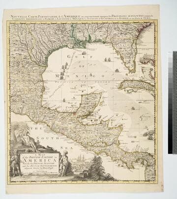
Map of the British Empire in America With the French, Spanish and the Dutch Settlements adjacent thereto by Henry Popple
Visual Materials
Kashnor notes, "Copied from Popple's map With the titles in English and French. ShoWs Carolina divided into counites, With Georgia and the Forts neWly erected, and Savannah." Kashnor dates as ca. 1740, RLIN record suggests 1755. Cartouche of Indians, traders. MS note: No. 10. Relief: pictorial. Projection: Cylindrical. Printing Process: Copper engraving. Other Features: Cartouche. References: McCorkle [741.2]. Verso Text: MS note: 326.
105:326 M

Carte du Canada ou de la Nouvelle France et des Decouvertes quiy ont été faites Dresée sur plusieurs Observations et sur un grand nombre de Relations imprimées ou manuscrites par Guillaume Del'Isle Geographe de l'Academie Royale des Sciences
Visual Materials
Kashnor notes, "The map still shows the territory around the southern part of Hudson's Bay as French territory, with Fort Nelson called Fort Bourbon, and Fort St. Louis on Moose River. The supposed Western Sea is taken from particulars furnished by La Houton." See 105:433 for earlier version, 105:432 for later. McCorkle identifes this as 1708 version. Cartouche with natives. Photocopy stored with map.. Prime meridian: Ferro?. Relief: pictorial. Graphic Scale: Miles, leagues. Projection: Pseudocylindrical. Watermark: C (symbol) I H (lettering). Printing Process: Copper engraving. Other Features: Cartouche. References: McCorkle 703.5. Verso Text: MS notes: Canada et Nouvelle France 105/431 Canada, ou la Nouvelle France. 3.
105:431 M

New and Correct Map of the British Colonies in North America Comprehending Eastern Canada with the Province of Quebec, New Brunswick, Nova Scotia, and The Government of Newfoundland: with the Adjacent States of New England, Vermont, New York, Pennsylvania and New Jersey
Visual Materials
Lays out boundaries of French fishing rights and shows old boundary of French territory of Quebec. See 105:308M for another copy. Kershaw lists a third state of this map with Laurie & Whittle as publishers, but dated 1st Jany. 1794, also gives appeared in information. Beaver surmounts cartouche.. Prime meridian: London. Relief: pictorial. Graphic Scale: Miles. Projection: Conic. Printing Process: Copper engraving. Other Features: Cartouche. References: Kershaw 717; LC Phillips 6009; McCorkle 794.12. Verso Text: MS note: 247.
093:247 M
Image not available
Map of the Provinces of Upper and Lower Canada with the Adjacent Parts of the United States of America &c. Compiled from the latest Surveys and Adjusted from the most recent and Approved Astronomical Observations by Joseph Bouchette
Visual Materials
Kashnor notes, " Dedicated to the Prince Regent by J. Bouchette, who was Surveyor General of the Province of Lower Canada." Elaborate cartouche with ships and Indians. Three engraved views by Bouchette: Grand Portage on Lake Superior; Cape Anguille and Cape Ray on entering the Gulf of St. Lawrence; Bird Islands.. Prime meridian: London. Relief: hachures. Projection: Pseudocylindrical. Watermark: Edmeads & Co. 1811. Printing Process: Copper engraving. Other Features: CartoucheVignettes. Verso Text: MS notes: 105 306 2 sheets.
105:306 M

A New Map of Nova Scotia and Cape Britain. with the adjacent parts of New England and Canada, Composed from a great number of actual Surveys ; and other materials Regulated by many new Astronomical Observations of the Longitude as well as Latitude ; with an Explanation
Visual Materials
Kashnor notes, "The first issue of Jefferys' map. It was re-issued twenty years later by Sayer and Bennett." Kershaw states this is the second state of Jefferys map. Prime meridian: London, Ferro. Relief: pictorial. Graphic Scale: Miles, leagues. Projection: Pseudocylindrical. Watermark: I Ville Ary under IHS Crowned fleur-di-lis over LVC. Printing Process: Copper engraving. Other Features: Cartouche. References: Kershaw 739; McCorkle 755.20. Verso Text: MS note: 668.
105:668 M